The viewpoint for the Hanging Glacier Falls at the end of the 3.3km
Saturday 18 January was the night I almost spent sleeping in a Chevy pick up truck. I had no idea CONAF would be so completely ridiculous!
I was looking forward to spending the day in Queulat National Park. Queulat National Park was created in 1983 and was largely inaccessible until the Carretera Austral opened in 1988. It is still visited by relatively low numbers. The name Queulat means “Sound of Waterfalls” in the language of the Chono people and the park’s most popular attraction is the Cascada de Ventisquero Colgante or Hanging Glacier Falls. I was going to hike to see this during my time in the park today.
The powerful Cascada de Ventisquero Colgante created by glacial meltwater
I arrived at the National Park at 11am. The National Park hours were 8.30am to 5.00pm, so I decided I would head for the boat first, in case when I came back from the Hanging Glacier Hike, it was too late.
In this part of Queulat National Park, basically all the hikes are to see the Hanging Glacier. Including the hike to the boat where a boat takes you across the lake to see the Hanging Glacier from the water. But it is pretty amazing to look at and I certainly didn’t regret hiking to see it from every angle.
Crossing the swing bridge over the racing Cisnes River on the first steps of my hike to the Hanging Glacier
I had paid my entrance fee to go into the National Park. The ranger takes all your statistics, name, passport number, where you’re from, which is very important because if you’re a foreigner you get to pay twice as much as the locals, £8 instead of £4. He also wanted to know where I had stayed the night before and where I was staying tonight. Asking where I was staying tonight was a bit of a nonsense as I’ll explain later.
Queulat National Park was created in 1983 and still visited by comparatively small numbers
The hike to the boat is 600m. As I said, I decided to do this first. It was just before 12 when I got to the boat launch and there was a family with 2 children and then another couple turned up. They said they needed 6 adults to run the boat, but they obviously decided 5 adults and 2 children was near enough, because they set off with the 7 of us.
An alternative view of the Hanging Glacier from a zodiac trip around the lake
My Spanish is limited, so I couldn’t work out if we stayed on the boat for the whole time or if we got off at the other side of the lake and there was a hike over there too. It turned out it was just a boat trip. There was no hiking trail at the other side of the lake. Having said that, the boat trip was wonderful, well worth it. My first real views of the Hanging Glacier were from the boat and I loved that perspective.
The Cascada de Ventisquero Colgante flows into the glacial lake
Next was the big hike, the 3.3km hike to see the Hanging Glacier. Again, it wasn’t clear if that was one way or return, neither was it clear whether the time of two and a half hours was a one way or return time. I’m still not sure about the latter, maybe at a push you could do it in two and a half hours if you were a speed hiker and had no stops, but an ordinary person doing the return journey in two and a half hours is a bit of a push.
Queulat means “Sound of Waterfalls” in the language of the Chono people
The thing I do know for certain is that 3.3km is one way. There is a fair bit of climbing to do, but it’s not too bad. It wasn’t as difficult as the hike I’d done in Laguna San Rafael National Park to see the Explorers Glacier. I did bring my hiking poles with me on this hike which certainly made things easier. In addition, I had picked up some good tips from hiking Volcan Villarrica and was using my poles more effectively as well.
Ventisquero Colgante viewed from the glacial lake
I met a couple of English lasses who had already been in Torres Del Paine and hiked the O Trek which meant they’d done the W Trek that I was doing plus a bit more. They said the W Trek was no worse than this one today, which was a relief. It meant I could probably manage it. I book these things with an expectation I might not be able to do them, so I was happy to hear the W Trek did sound like it was within my limitations after all.
Part way along the 3.3km main trail to view Ventisquero Colgante
The trail to the Hanging Glacier was a bit muddy and a bit steep in places, but not too bad and certainly nothing like I’d encountered on the Explorer’s Glacier trails, particularly the first one I did. The view at the top was amazing, but it was quite crowded, there were a lot of people up there. I spent half an hour taking in the view and taking photographs and then headed slowly down, with my new found volcano/mountaineering pole skills helping in abundance.
The Hanging Glacier is the star of Queulat National Park
The swing bridge is right at the start (or end) of the trail and I wanted lots of photos on that too. I did the short nature interpretive hike and then went back to the swing bridge where there was no one to disturb my photo taking. I didn’t realise why at the time. This I was to discover.
There was only one more trail left to do, the panorama of the glacier, where you see it again from another perspective. I’d done 8km today, what was another 400 metres?
It’s a 3.3km uphill hike to the viewpoint of Chile’s famous Hanging Glacier
I couldn’t decide whether this was an even better view of the Hanging Glacier than the others I’d seen. I’d need to look back on my photos to check. But it was certainly a fabulous view. I stayed up there a while. Two other couples turned up. They left. I had the place to myself. I started walking down the track and held onto the hand rail and felt what I thought was a nail that had dug into my hand. It wasn’t a nail, it was a caterpillar. I’d not even looked and put my hand on it. And it really stung. For about 5 hours. The deadly poisonous South American Lonomia caterpillar which has a poison that can kill humans thankfully isn’t found in Chile. But whatever species had stung me, it really hurt. I regretted being so careful and not stabbing one with my hiking pole or standing on one earlier if this was the thanks I got. And my day was only about to get worse.
View of the swing bridge from the nature trail
I finally went down the wheelchair accessible route to take in the view from this 50 metre trail, took more photos and headed back to my pick up truck.
There were 3 vehicles left in the car park. I started up and drove down through towards the exit. Then I got to a closed gate. I got out of the pick up to open the gate. Then I saw it was padlocked. Padlocked? And not even with one lock, with two padlocks! What? When I’d driven in, I hadn’t even noticed a gate because it had been open. Why would they padlock a gate when they could see there were still cars in the car park? It had never even occurred to me that what “hours of operation” actually meant was that after 5pm they would padlock the gate so that no one could get in or out.
Posing for photos on the swing bridge on my return journey wondering why no one else was about
I could understand if they didn’t want anyone else getting in after 5pm, but surely they could have an electronic gate that could stop people getting in, but would at least let people out. It was well before 7pm at this stage. It wouldn’t even start getting dark for another 3 hours. 5pm seemed ridiculously early to go to the extreme of padlocking a gate with 2 padlocks.
I wasn’t the only one who was caught out. Another couple were also trying to leave. Some campers were arriving. This was ludicrous.
View of the Hanging Glacier from the Panorama Trail
I started out with mad ideas. Something to pick the locks with, although I haven’t the first clue how to pick a lock even if I did have the right tools. Maybe I could just crash through the gate like they did in the Dukes of Hazzard! I was being ridiculous. Almost as ridiculous as CONAF, the Chilean National Park Service double padlocking a gate at 5pm in the middle of summer.
I had some more sensible ideas then. Park up for the night and get a taxi to my accommodation. The nearest taxi was in Puerto Aisen, 4 hours away. Okay so maybe ring my accommodation and ask them to do me a favour and pick me up. No mobile reception. A night in the pick up truck was looking more and more likely.
The glacier hanging off the side of a mountain is part of the Queulat Ice Cap
I drove to try and find someone and picked up some Chileans who had turned up too late to camp. They spoke some English. I offered them a lift. Normally I don’t pick up hitchhikers, but they weren’t hitching, I needed help and they spoke Spanish, I had the equivalent of £20 cash in my purse and they were hardly going to steal my pick up truck were they, they couldn’t bloody go anywhere, the exit gate was double padlocked.
The Hanging Glacier is part of the Queulat Ice Cap which forms part of the huge Patagonian Ice Field
They spotted a couple of cars in a house that was probably inhabited by CONAF staff and a pick up truck was coming out of there. I speeded up to block the exit and the Chileans got out to speak to him. He said he would unlock the gate for me and sort out the Chileans camp site for them.
The glacier is just visible in the distance behind me
When he unlocked the gate I said thank you very much in Spanish, he just scowled and pointed at his watch. I was immediately in a bad mood again. He was in the pick up truck, he was going out anyway, he would have had to unlock the gate. A Chilean couple had been caught out. I imagined this happened all the time during the light nights of the summer. Miserable sod. Ridiculous regulations. Plus it had taken about an hour to find someone to unlock the gate. So I wasn’t that late, I’d just been trapped.
Final view of the Hanging Glacier in Queulat National Park in Northern Patagonia
I had some cheap red wine at my bed and breakfast that was completely revolting. Revolting or not, I needed a drink after that ordeal!
I travelled to Queulat National Park during my time driving on the Carretera Austral in January 2020.
Queulat National Park is run by CONAF, the Chilean National Park Service. The entrance fee is approximately £8 for everyone apart from Chilean nationals who get in for half price. The opening hours are 8.30am to 5pm in summer. Be sure to check the opening hours so you don’t get trapped inside like I did!
Queulat National Park is approximately 30 minutes drive from Puyuhuapi. Puyuhuapi is 230km north of Coyhaique on the Carretera Austral and takes around three and a half hours to drive.
I stayed at 2 different places in Puyuhuapi.
Hostal y Cabanas Ventisquero costs approximately £22 per night for a small, but comfortable room with ensuite bathroom. I booked through booking.com.
Hosteria Alemana costs approximately £30 per night for a single room with ensuite bathroom and breakfast included. I booked directly with the guesthouse. Details of the accommodation can be found on Trip Advisor.
I booked my pick up truck with Keddy by Europcar through an intermediary in the UK. It cost me approximately £52 per day for a 4WD 4 door pick up truck.
My trusty, sturdy, reliable, 4WD Chevy pick up truck
To access the Carretera Austral, I flew to Balmaceda Airport from Puerto Montt with Latam which cost £54 return. Checked luggage and seat reservation are extra.
Further information about driving the Carretera Austral can be found in my post
Enjoying a glass of whisky cooled with ice fresh from a nearby iceberg
Laguna San Rafael is a lake formed by the San Rafael Glacier, one of the many wonderful glaciers of Patagonian ice field. This was a place that I had read was fairly inaccessible and not seen by anywhere near as many people as somewhere like the Perito Moreno Glacier in Argentina. This was precisely the reason I was determined I was going to see this glacier from the massive ice field that was part of San Rafael National Park in Northern Patagonia on the Chilean coast, right next to the Pacific Ocean.
It had not been easy to arrange in advance. Nothing about Northern Patagonia was easy to arrange in advance. Once you got here, everything was easily available to do, but finding information to make a reservation outside of Chile was incredibly difficult.
This cabin was home for 2 nights
I actually would have been able to go to Laguna San Rafael from Puerto Tranquilo, had I been able to get up to date information from the internet. You can access Laguna San Rafael National Park from Puerto Tranquilo. But I wasn’t able to find this information in advance, so instead I booked through Hotel Loberias del Sur in Puerto Chacabuco which was on the internet, but it meant I had to send a reservation by post from Riga, as I was working in Latvia at the time. If I’d turned up on the day at the hotel, I would have got on the trip. So there had been no need to panic. I had been told back in October that the trips often got fully booked, but I suspect you’d have to be unlucky to turn up on the day and find there was no space. If you wanted to make extra sure, I think booking the day before would generally guarantee you a place.
Beautiful wooden staircase in my cabin leading up to the main bedroom
Puerto Chacabuco is near Puerto Aysen, much further north on the Carretera Austral than Puerto Tranquilo. I was going to have to head back that way in any case, but it was a detour off the main road. It would also mean spending a much longer time on a boat to get to the glacier than I would have from the Valley of the Explorers which was a very short hop in comparison.
However, I did get to see a different part of Northern Patagonia, I stayed in a wonderful log cabin in the middle of nowhere and the boat trip turned out to be a brilliant day.
Main bedroom in the cabin
The boat was only about two thirds full, which meant there was plenty of space. There were 6 seats to a table, I got a window seat and my table was shared by a couple from Israel and a bloke from Switzerland. The couple had hired a car and were driving the Carretera Austral. They had started in Puerto Montt and taken the two ferries to get here. They were driving back through Argentina. The Swiss bloke was touring around on his motorbike and had had his own motorbike shipped over from Switzerland for the journey.
We set off for the Laguna San Rafael from Puerto Chacabuco at just after 8 o’clock in the morning. It was 125 miles to reach there by boat and this was going to take at least 4 hours. We were weaving through inlets to reach this massive ice field in Laguna San Rafael National Park and it was slow progress. However, since this was quite an expensive thing to do, over £200 for the day, the food and drink was all included.
It took several hours for this boat to weave through the coastal waterways from Puerto Chacabuco to reach the San Rafael Lagoon
We started off by having breakfast and enjoying the scenery as we sailed and I got to know the passengers who were sitting at the table with me. Thankfully they all spoke English. The Chilean people were generally sitting together. There only seemed to be a few people on the boat trip today who weren’t from either Chile or Argentina, including a family from Colorado who I got chatting to later.
The excursion staff spoke both Spanish and English and gave us information about the Patagonian ice field and glaciers. I chatted to my fellow travellers a little more and we talked about our experiences of driving along the Carretera Austral. And it was actually quite nice to have a day off driving.
Adventure to see the rather inaccessible San Rafael Glacier
As a pre-lunch aperitif, the staff came round with glasses of Pisco Sour for everyone. Pisco Sour is something everyone drinks if they come on holiday to Chile. It’s the law. There’s a debate about whether pisco, a type of brandy, originated in Peru or Chile and where the cocktail comes from. I’ve never been to Peru, but I’ve been to Chile twice, so I’m fiercely loyal to Chilean pisco and their version of the Pisco Sour. We had lunch to soak up the alcohol as we got closer to the glaciers.
On many excursions to glaciers, including the other ones I did in Chile and Argentina on this trip, as well as those I’ve done in Alaska, you stay in the main boat to see the glacier and it gets as close as is safe to do so. But this trip was more of an adventure. Instead of staying on this relatively large boat to get as close as possible to the glacier, we were going in zodiacs!
We ventured out in this zodiac to get close to the San Rafael Glacier and nearby icebergs
Our boat anchored and we were called to the boarding point to get into the zodiacs. We got kitted out in our life jackets and then, in turn, we were called into the zodiacs. I had zipped around in zodiacs quite a lot when I went to Antarctica, as these inflatable boats were the preferred modes of transport to do landings around the Antarctic peninsula, but I hadn’t been in one since. And now I was going on an adventure around the icebergs and glaciers in an inflatable boat in Patagonia. How exciting!
One of the small icebergs we passed on the zodiac ride
I got into the zodiac and sat next to my new Swiss friend and we headed out into the lake towards the glacier for a closer view. Laguna San Rafael is a lagoon formed by the retreat of the San Rafael Glacier and the calving and melting of this glacier means that the lagoon is filled with icebergs, the pieces of ice that have broken off from the edge of the glacier. You get a real sense of the size of these icebergs when your only protection from them is an inflatable dinghy. They are enormous! Being in a zodiac meant that we could weave in and out of the icebergs much more than a normal boat could do, so we could get relatively close to them. It was amazing to be able to see the icebergs from the zodiac as we moved past them and closer to the San Rafael Glacier.
The icebergs are getting bigger
It’s difficult to tell how close you are to the glacier from the perspective of the boat or if we were closer to the glacier in the zodiac than I had been when I’d been in normal boats, but you certainly get more of a feeling of the danger when you’re in an inflatable dinghy that could easily be overturned by a massive upsurge caused by a huge segment calving off the edge of the glacier.
Even in the middle of January, the height of the Patagonian summer, this sheltered lagoon of glacial water was freezing cold. The icebergs were not melting like a snowman in the midday winter sun. The temperature meant that the icebergs were diminishing at an extremely lethargic pace. So if an enormous chunk of ice fell off the toe of the glacier and into the lagoon, it would cause an immense wave that could flip our zodiac if we were too close to the glacier. And if that happened, then we would all fall into the icy lagoon. We had our life jackets, so we wouldn’t drown, but the water temperature would be a recipe for hypothermia rapidly setting in and death in a matter of minutes. So it wasn’t a good idea to get too close to the glacier in a boat of any description, never mind a small, inflatable one.
Viewing the San Rafael Glacier from a zodiac on the San Rafael Lagoon – the glacier is much further away than it looks
The glacier looked gigantic in front of us and it didn’t look like it was very far away, but I never felt like we were close enough to it to be in any real danger. Tourist trips by boat to Laguna San Rafael were done fairly frequently. The crew should know what they were doing.
After spending plenty of time weaving through the large icebergs and smaller chunks of ice that floated on the lagoon and getting as close as we dared to the edge of Glaciar San Rafael, with ample opportunity to take lots of photos, the zodiac steered back towards the big boat.
There are plenty of icebergs in Laguna San Rafael that have broken off the glacier
The zodiacs didn’t take all of the passengers out to the glacier at the same time, so after our group was back on board the main boat, we could watch as our zodiac took another group out for a closer view of the glacier. From this viewpoint you really could see how tiny the zodiac was in comparison to the glacier and surrounding icebergs. I enjoyed watching the zodiacs heading out towards the glacier, momentarily disappearing behind large icebergs and then magically reappearing. This was a truly enchanting place to be in the world.
Once everyone was back on board it was time to make the long journey back to Puerto Chacabuco. I was expecting it to be quite dull, but actually it was a brilliant trip back.
We are close enough to the iceberg to see how the surface of the lagoon has shaped it
The crew announced that for our entertainment on the way back, we were the entertainment, it was karaoke time! I groaned, what was this, a booze cruise in Ibiza? The crew came round and served us a glass of whisky cooled with ice collected from one of the icebergs on the lagoon. The Swiss man and the couple from Israel, who appeared to be as impressed as I was at the prospect of a load of tourists singing out of tune for several hours, probably in a foreign language, disappeared onto the lower deck of the boat soon after that. I had another glass and settled back to relax and listen to the karaoke. I would retreat to the lower deck as well if things got too ghastly.
The largest ice field in the Southern Hemisphere is in Patagonia, so it’s not surprising I saw lots of glaciers there
As I predicted, since most of the passengers on the boat were Chilean we had a lot of passengers volunteering for karaoke and singing songs in Spanish that were evidently beloved in Chile, but unknown everywhere else in the world. It seemed to be the same few passengers who were doing the karaoke, which is fairly typical in my experience. It was an open, free bar, so I took advantage and sampled a couple of different types of Pisco and also some tequila, which were all very good quality.
It might have been the fact that I was on a high after the zodiac to the glacier or I was emboldened by the strong booze, but I decided I was going to have a go at the karaoke and I went up to the staff who had a laptop with thousands of songs to choose from. I didn’t know any Chilean songs, I wasn’t able to sing in Spanish and I also thought it was about time for Europe to be represented, so I requested Mamma Mia by Abba, probably the most European of all bands. Thankfully as Abba was a world famous pop band in the 70s and 80s, followed by the success of Mamma Mia on the stage and big screen, my fellow travellers from South America knew the song. I had fun singing it and having a bit of a dance on deck. I do love to sing and dance. I’m not bad at both singing and dancing, but I wouldn’t win any competitions in them either.
We got very close to this giant iceberg in our inflatable boat
After my initial song, which had generally gone down well because I’d sung a recognisable song and managed to carry a tune, there were more Chilean classics sung by the locals and when there was another gap, I decided that it was time for England to be represented and which better band to represent the English than the most successful band of all time? I chose my favourite Beatles song, All My Loving which had the added bonus of being short and without lots of key changes. I even managed to do the high bit at the end! The booze had definitely emboldened me to do that!
One of the women from the family from Colorado on the boat had obviously decided I had a good voice and asked me to sing with her.
Enjoying my free drinks with ice freshly hacked from an iceberg in the lagoon
My two rules of karaoke are, make sure you know the song really well and could sing it without the lyrics if necessary and make sure it’s a song you can actually sing. I once did a very drunken rendition of “Take Me Home Country Roads” in a pub in Torquay, a song I love and know backwards, but which wasn’t in my key and sounded appalling! That was fine in the car when no one was listening to me, it was not fine in a pub full of people.
Getting close enough to the iceberg to take ice for our drinks
The woman from Colorado had requested the Gershwin classic “Summertime” originally recorded by Ella Fitzgerald. If ever there was a definition of punching above your weight, me trying to sing an Ella Fitzgerald song was it. This song broke both of my karaoke rules, it’s a song I don’t know particularly well and it was a complicated melody with some very low notes that anyone who isn’t a professional singer would struggle with. I didn’t get beyond the first few lines before I’d given up. In order to prove that I could sing, I just didn’t have the vocal capability to perform an operatic aria, I did one more song on my own. “Top of the World” by the Carpenters is a particular favourite of mine to sing at karaoke, so I knew I could make a half decent job of that one!
After all this karaoke, time had flown by and we were getting closer to Puerto Chacabuco. I sat down as tea was served and the other members of my table returned for our final approach into the town. We got back to Puerto Chacabuco at around 7pm. It had been a full day out.
San Rafael Glacier flowing into Laguna San Rafael
The cruise from Puerto Chacabuco to the San Rafael Glacier had been very enjoyable and had exceeded my expectations. The main feature that put it well above all of the other glacier excursions I did, was the fact that we went out to the glacier by zodiac. That made it a unique and special experience. In addition, the long journey sailing through the inlets to reach the glacier meant that I had had time to get to know some of my fellow passengers. It was a leisurely day that gave me a rest from driving and a chance to relax. And the karaoke wasn’t half bad either!
I travelled to Laguna San Rafael during my time driving on the Carretera Austral in January 2020.
I booked my all day trip to Laguna San Rafael with Hotel Loberias del Sur in Puerto Chacabuco. The 12 hour excursion including trip to the lagoon by boat, close up excursion to the glacier by zodiac, all meals and alcohol drinks, cost around £225. It is also possible to stay at overnight in the hotel.
Puerto Chacabuco is approximately 20 minutes drive from the major settlement of Puerto Aisen. To reach Puerto Aisen turn onto Road 240 from the Carretera Austral, just north of Coyhaique. It will take approximately an hour to drive the 64km to Puerto Aisen.
I stayed at Cabanas Ecoturismo la Pancha 7km outside of Puerto Aisen. A 3 bedroom cabin costs approximately £78 per night. The hotel is also on various hotel booking websites. I booked through booking.com.
I booked my pick up truck with Keddy by Europcar through an intermediary in the UK. It cost me approximately £52 per day for a 4WD 4 door pick up truck.
My trusty, sturdy, reliable, 4WD Chevy pick up truck
To access the Carretera Austral, I flew to Balmaceda Airport from Puerto Montt with Latam which cost £54 return. Checked luggage and seat reservation are extra.
Further information about driving the Carretera Austral can be found in my post
Laguna Torre with Glacier Torre and Glacier Grande behind me
I made a lot of bad decisions about my travels in Argentina. Staying for 2 days and 2 nights in El Chalten wasn’t one of them.
I had read that the hiking there was wonderful and certainly the two hikes I did were thoroughly enjoyable, even though they were very tiring and I could barely walk by the end of the day.
View of the Rio de las Vueltas Valley from my hike to Mount Fitz Roy
I arrived in El Chalten early in the morning after the 24 hour bus ride from hell from Bariloche. I’d had less time than normal to research and when it came to this part of the trip I’d made the worst possible choice at every turn. I could have got the normal bus to Bariloche, arrived at a reasonable hour instead of it taking me all day from Puerto Varas. I could have got a direct flight from Bariloche to El Calafate and hired a car for my time in Argentine Patagonia. Or I could have missed Bariloche altogether and got a flight to Punta Arenas, the bus up to El Calafate and hired a car for my time in Argentine Patagonia.
As it was, I got the bus from Bariloche to El Chalten. I had travelled on a long distance bus 7 years ago between Puerto Iguazu and Buenos Aires, which had taken around 18 hours and went through the night. That was actually quite comfortable, almost fully flat reclining seats, a curtain across for privacy, food and wine and we didn’t get kicked off in the middle of the night for the driver to have a break. Other than one stop at around 5am when the Argentine military came on the bus to do a check, there weren’t any disturbances. It wasn’t bad at all.
Mount Fitz Roy
Fast forward to 2020 and standards had gone down. I can’t remember which bus company I used in 2012, but Marga Taqsa were the company I used this time. Before I even got on the bus, I saw what a mess it was from the outside. And then the first thing I saw when I got on the bus for this 24 hour plus journey was a sign on the toilet door saying “Don’t Work”. No curtains for privacy, the seats didn’t fully recline. The seats were quite wide and I had reserved my seat right at the front of the bus on the upper deck so I had a decent view. That’s the only good thing I can say about it. We were given food twice, both times a sandwich with a slice of an unfortunate dead animal in it which, as a vegetarian, I didn’t touch, a stale mini bread roll and a biscuit which was the only edible thing on the plate. And a half cup of squash.
We made several stops for toilets. All the bus stations we stopped at were grotty with grotty toilets and no loo roll in any of them. No stop through the night for the toilet. I was seriously dehydrated by the end of the journey because I daren’t drink. It was a horrific experience.
Mount Fitz Roy hidden by cloud at the viewpoint
This was further compounded when I came to leave El Chalten 2 days later and found I’d missed my bus because the time had changed to 1 hour 20 minutes earlier than on my ticket and I was told it was my responsibility to check the website for time changes, not their responsibility to send me an email to inform me of the changes, like you’d get with any professional business. The other bus company I used in Chile didn’t even change any times and still sent me an email the day before I travelled confirming my reservation and the departure time.
Luckily there was another bus out of El Chalten, even though it was over 4 hours later, which I got my ticket transferred to. I’ve learnt in a lot of Latin American countries, complaining does no good and they don’t care about bad reviews. I was just pleased that this was the last time I’d be using this bus company and hoped that the subsequent, much shorter journeys I’d be taking by bus with a Chilean company were much better, which thankfully they were.
The mountains you can see from Mirador del Fitz Roy on a clear day
I dropped my luggage off at the bed and breakfast but it was so ridiculously early I knew the room wouldn’t be ready. I was able to stop and have a cup of tea, then I went to the National Park Centre and found out about the hikes. There was a waterfall hike, two short hikes near the centre and then the two main hikes in this part of Los Glaciares National Park, the hike to Mount Fitz Roy and the hike to Laguna Torre. It was a better day weather wise today, so I was advised to go to the viewpoint of Mount Fitz Roy and leave Laguna Torre until the next day because the hike would take all day and I’d still see the glacier. I was told the waterfall hike was the easiest in the park, so to do that one too, plus the two short hikes near the centre. I decided against doing the ones near the centre, but that I would do the waterfall hike that morning before checking into the B&B. Unfortunately my rucksack was really heavy and as it had all my valuables in it I was reluctant to leave it unattended at the B&B.
Getting a peak of the top of Mount Fitz Roy
I walked to the start of the waterfall trail which was about 2km and then decided that I wasn’t going to do another 6km with a heavy rucksack, I was going to abandon that idea and wait until my room was ready at the B&B and hike with a lighter load.
The town of El Chalten was backpacker central. It didn’t have any charm about it at all. You could tell it was a place geared to backpackers because on every corner there was a launderette. I’ve never seen as many launderettes in one town! There were also a lot of hostels charging about £7 a night. I dreaded to think what sort of place you’d get to sleep in for £7 a night. All the restaurants advertised cut price menus and happy hours. As it turned out, I was so exhausted after my hikes that I wasn’t interested in eating a large meal or boozing at the end of them anyway, I just collapsed into bed at night.
Enthusiastic about making it to the Mirador for the wonderful views of Mount Fitz Roy
My room was ready just after 12, so I checked in, took as much stuff out of my rucksack as possible, got showered and changed to get myself clean after spending 24 hours on the disgusting bus from Bariloche and I was ready to hike.
I went back the 2km through the town, which was a lot bigger and more spread out than you might imagine since it was only supposed to be a small place, and decided I would leave the waterfall for later, now I was going to do the viewpoint to see Mount Fitz Roy which was 4km one way.
Mount Fitz Roy peak is visible as the cloud had cleared by the time I got to the lake
The full hike of Laguna de Los Tres to the glacial lake at the foot of Mount Fitz Roy is about 10km each way, but it was apparently quite a difficult hike, especially the last kilometre or so. I passed some people who had done the full hike and said it wasn’t easy. I had set off far too late to do a 20km hike today, even with the extended daylight hours of the Patagonian summer, so I just hiked 4km to the viewpoint to see Mount Fitz Roy.
The hike wasn’t a particularly difficult one. It was a long, continuous, uphill climb to start with, but it was just a case of keeping going until I got to the top. I got a bit out of breath as anyone would with a long, uphill slog. However, it wasn’t too bad and I was reasonably fresh after resting and not doing very much for the last few days, travelling to and from Bariloche and spending time in the city. I kept looking up to see how much further it was to the top. I made it up there eventually.
People staying at the campsite here have an amazing view of these Andean mountains
The hike got easier after the climb. The trail flattened out and after that it wasn’t much further to walk to Mirador del Fitz Roy.
The views from Mirador del Fitz Roy were wonderful. The mountain was obscured a bit by cloud, but you could still see it. A friendly, young Argentinian couple took some photos for me with the mountain in the background and they turned out quite well. I stayed for a while chatting to the couple and enjoying the view. I have a tendency to do a long hike, stay for a couple of minutes to see the view and then set off back. Today I was going to stay and enjoy the location for a while.
A view of the valley on my descent from Mirador Fitz Roy
By now it was too late in the day to have continued further to get all the way to Laguna de Los Tres even if I’d wanted to. However, there was a campsite nearby, next to a lake and I would be able to get another view of the mountain from here. It wasn’t far to walk at all and the cloud had cleared by this point so I got a good view of Mount Fitz Roy behind me, although the man who I asked to take some photos for me was a pretty useless photographer, so the pictures with me in them certainly could have been better.
It wasn’t a bad hike down either. Sometimes when I’m going downhill, it’s a bit precarious and takes a long time, but this trail was okay. In some spots there were some big steps down and I had to take care, but it wasn’t particularly steep and these days I never go on any long hikes without my poles, which generally make it easier.
Chorrillo Waterfall – not worth the effort of a 6km hike
There was still plenty of daylight left when I finished the trail, so I decided that I would go and see Chorrillo Waterfall that I’d missed earlier in the day.
If anyone reading this is tempted, don’t bother. If you have a car and only have to hike a couple of hundred metres from the car park to see it, go and have a look. If you have to do the 6km round trip from El Chalten, it’s not worth the effort. I’ve seen far better waterfalls. The walk mostly takes you along the side of the road to get to the car park too, so it’s not even an interesting walk to get there. And when I got back to the trail head I still had the 2km left to walk to get back to my accommodation. My step counter might have slightly over exaggerated how far I’d walked, but according to it, my 47,500 steps translated into almost 24 miles. I could barely put one foot in front of the other.
Fitz Roy River cuts through the valley
Next day I was feeling tired. I hadn’t slept very well, mainly because of the infamous Patagonian howling wind that had been raging all night. I’d been told not to leave the windows open without hooking them because the winds were so strong they could slam the windows shut and break the glass. After listening to those winds all night and expecting the ceiling to cave in, I could well believe that.
I was debating whether to do the hike to Laguna Torre today. The strong winds had really put me off. But what else was I going to do all day in El Chalten? I should at least go and see this viewpoint of the glacier, although I had been informed by the ranger yesterday that the hike to the glacial lake was not difficult.
The hiking trail ahead of me, still 8 km to get to Laguna Torre
At half past eleven in the morning, bundled up in two coats, a hat and ski gloves, I set off to do the trail.
The wind was starting to die down and I was immediately far too hot. The hat and gloves came off almost straight away, as did one of the coats.
The first 3km of the hiking trail were the most difficult
The first 3km of the hike which was to the viewpoint was quite tough. It was all uphill.
After the first kilometre or so there were some fabulous views of the valley below and I took a break to take a few photos and enjoy the scenery.
More views of the Fitz Roy River
The next couple of kilometres were a further ascent and there were some pretty steep sections where you had to clamber up some high boulders to progress on the trail which was quite an effort. However, it was going to be a lot more difficult when I was going downhill. I put that out of my mind for the moment.
One very handy thing on this hike though, was the signposts. You actually knew how far you had walked and how far you had to go. This was a 9km hike and at every kilometre there was a signpost 1km of 9km, 2km of 9km. You get the idea. So you could track your progress.
View of the Andes on the first stage of my hike
After 3km I reached the Mirador del Torre. The views of the distant glacier and surrounding mountains were amazing. As I sat resting at the viewpoint I started chatting to an English bloke who lived in Canada who said he had done the whole 9km hike to the glacier. He said it was fairly easy until you got to the moraine and even then that was clearly marked. He said that he had done it in about 2 hours.
It was after 2 o’clock by now. So I had to decide, did I push on, give myself a time when I had to turn around and then extend it as much as I dared so I wasn’t hiking in the dark to do this full hike or did I head back to El Chalten. Back to El Chalten to do what? I decided to try and get to the glacial lake and do the full hike.
Mirador del Torre is the viewpoint for Glacier Torre
The first 3km of the hike up to Mirador del Torre were by far the most difficult. The next 6km was fairly flat for the most part and I actually completed it in less than 2 hours.
The terrain was generally fine for walking, although there were some parts where I was walking through fairly dense brush. However, there was a visible, if narrow, path which sometimes forked, but the paths always merged back into one again, so you couldn’t get lost. You were never too far from the river either, which made it fairly easy to navigate. The views were amazing, I was walking past mountains and glacial rivers; it was a thoroughly enjoyable walk.
I’m happy when I’m hiking!
I chatted to a lone female American hiker who was camping close to the lake overnight. She took some photos of me. She was walking faster than me and wanted to get to the campsite before it got dark, so she could put her tent up in the daylight, so she left after a few minutes, but I stayed and enjoyed the view a bit longer. I got some beautiful photos that looked like they were in black and white, even though they weren’t. The glacier and mountains in the distance were white and grey, the sky and clouds were white and grey and even the trees and shrubs were mostly a silvery colour. There was just a hint of dark green ground cover vegetation, but it was very subtle.
At this point I had hiked about 7km and was still making excellent time, so there was plenty of time to push on to Laguna Torre. The next part of the hike took me further through the valley right to the moraine. The moraine was the last obstacle before I got to the glacial lake, it was just a case of climbing it to reach the lagoon beach.
My favourite view of the distant glacier through a valley of winter trees
The walk across the moraine was actually quite easy and I found the path of least resistance, which I always follow, and probably meant that I ended up doing a slightly longer distance than the one advertised. However, after a relatively straightforward climb over these large rocks, I was down at the glacial lake.
I loved the lake. It had icebergs floating in it that had calved off the glacier and there was a beautiful view of Glacier Torre and Glacier Grande. The weather was closing in now, there was a lot more cloud cover than there had been earlier. You could still see the glacier and the mountains but they were shrouded in cloud. I rather liked that.
Glacier Torre and Glacier Grande feed Laguna Torre in Los Glaciares National Park
I had made it here in under 2 hours, which meant I didn’t have to worry about running out of daylight, so I was able to spend a good bit of time at the lake. There were a few people there, but there was enough space for me to find my own spot on the beach and then I set up my phone with my gorilla grip for some photos. If people were looking at me, I really didn’t care. My photos with the gorilla grip usually turned out better than the ones people took for me. It always amazes me how bad most people are at taking photos. I did get a few good photos with the gorilla grip.
Then it was that time. That time when you have to turn round and walk back. This was not a circular route. I had to go back the same 9km route I’d just walked.
On the beach at Laguna Torre
At first I quite enjoyed it. It was that fairly flat and easy terrain to get back to Mirador del Torre and the return journey took about the same amount of time it had taken me to walk there. I made a quick stop at the viewpoint which was much quieter now and took a few more photos, although with the increased cloud the view wasn’t as clear.
Then it was the last 3 kilometres. Going up had been reasonably difficult. Going down was much harder. Even with my poles I struggled. When I tried to speed up if I was getting a bit fed up of walking so slowly I’d end up stepping on a loose stone and almost losing my footing or digging my poles in to keep my balance. I couldn’t go down on loose and uneven rock quickly. I simply didn’t trust myself. I had to be careful. I didn’t want to end up with a broken ankle or a broken neck.
The hike follows the course of the Fitz Roy River
Of course, it’s always worse when you’re tired. And when I finally got to the end of the hike, I still had a steep hill to go down to get me back to the road into the town. It was very loose dirt on that hill and I nearly went flying a couple of times. It was ridiculous. I’d survived the hike to the glacial lake and back. I couldn’t fall on my way down the hill into the town!
It had been another long and tiring walk, but it had also been immensely enjoyable. I was pleased that I had made the decision to go on the walk despite the howling winds earlier in the day. The first 3km of the trail to get up to the viewpoint were pretty hard going for me, especially on the return journey. I have to admit I didn’t enjoy walking down from the viewpoint. But the 6km from the viewpoint to the glacial lake were fantastic. It was a quiet trail; I enjoyed the scenery and the solitude.
View of the glacier on my return journey
The B&B was much further away than I remembered after I got to the bottom of the hill into El Chalten. When I finally got back to my room I was completely exhausted. However, I’d done another 20 miles today which made me more confident that I could manage to do the W Trek in Chilean Patagonia after all, when I’d had serious doubts up to now. This had been very good preparation for hiking the long distance trail in Torres del Paine next week.
I travelled to Los Glaciares National Park in January 2020.
Hiking in this part of Los Glaciares National Park is free of charge. For information about the hikes from El Chalten, the excellent tourist information centre across the bridge from the town has lots of useful information.
I did 3 hikes in Los Glaciares National Park, Laguna Torre which is 18km return, Laguna de los Tres as far as the viewpoint of Mount Fitz Roy, approximately 8km return and Chorrillo del Salto to the Chorrillo waterfall which is 6km return.
I travelled to El Chalten by bus from Bariloche. The journey takes 24 hours and it cost me £100. I used Marga Taqsa bus company, but I would not use them again and would not recommend them. £100 is very expensive for an uncomfortable bus with a broken toilet and inedible food.
There are direct flights from Bariloche to El Calafate with Aerolineas Argentinas for around £130 and you can rent a car in El Calafate to drive to El Chalten, which would be my recommendation.
I did complete the W Trek in Torres del Paine. Read the three part series about my experience.
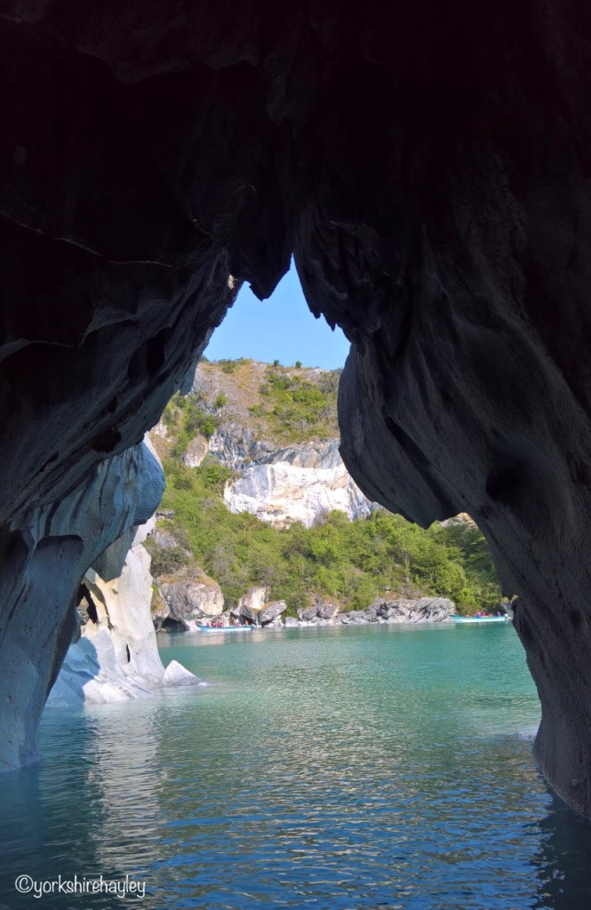
The amazingly beautiful coloured marble that makes up the marble caves in Patagonia
I had wanted to drive along the Carretera Austral for as long as I’d been seriously planning a trip to Patagonia. The points I wanted to see along the way were rather more fluid. But ever since I’d seen photos of the Marble Caves, I knew I had to see them for real. So driving as far south on the Carretera Austral as Puerto Tranquilo so that I could realise this dream became part of my route plan.
Getting up close to the Marble Cathedral
I had decided not to drive any further along the Carretera Austral than Puerto Tranquilo as I had no real desire to drive to the end of the earth. I’d been to the end of the earth several times in the past, I felt my time could be better spent exploring other parts of Patagonia than Villa O’Higgins, a long way from anywhere, not much there when you arrived and a long drive back. But driving as far as Puerto Tranquilo to see the Marble Caves was a necessity for me and I was praying the weather would be good so that I got to see them in all their glorious colours.
The view from inside one of the caves
I had arrived in Puerto Tranquilo the night before, after driving the 200km from Balmaceda Airport. I had already checked out the location of Bahia Mansa who were 5km out of town and I’d read about in an excellent online review and was now driving back there first thing in the morning to do a tour of the caves. It was best to do a tour in the morning when the light was at its best and also while the weather was still fine.
The weather conditions allowed us to get inside one of the marble caves in our boat
I had read that if the weather was bad it wasn’t possible to do the boat tour to the Marble Caves and I would have been devastated if I’d travelled all that way and didn’t get to see them. However, I had given myself 2 nights in Puerto Tranquilo, so if the weather had been terrible on the first day, I had a second morning to attempt to see them. In addition, it was the Austral summer and I was a long way south, so I had plenty of daylight which meant it wasn’t necessary to set off anywhere at daybreak to ensure that I wasn’t driving in the dark, which I was trying to avoid on the Carretera Austral. The next day I was driving to Puerto Aisen which was around 300km away and would probably take about 6 hours. So even if I set off at midday from Puerto Tranquilo, it wasn’t going to be an issue.
Some of the many marble caves that are found around the base of the Marble Cathedral
This morning the weather was perfect. The further south you drove on the Carretera Austral, the worse the road conditions and the drive from the town of Puerto Tranquilo to Bahia Mansa where I was getting the boat from, was on rough gravel until you got to the turn off for the property. Then it was a kilometre of one of the worst roads I’d ever driven on, steep downhill, rutted, hairpin turns. I was praying I wouldn’t meet anything coming in the opposite direction and I was lucky. I parked up and made my way to the little house where the family business operated from.
Our second approach to the Marble Cathedral to get more photos
The Marble Caves are found on Lago General Carrera, a massive freshwater lake fed by glaciers in Northern Patagonia. They are only accessible by boat. There were plenty of companies in Puerto Tranquilo that packed their boats full of tourists and gave limited time at the caves. The fact that I had driven to this small family run business that not many people knew about meant that I only had to share a boat with one couple so it made getting photographs a lot easier as I could move around the boat and we would have a bit more time.
Sailing around the Marble Cathedral in a small motorboat
The rock formations that rise out of the lake and have eroded and exposed their beautiful colours, dot all around this part of the lake. Rather than it just being one cave, there are several parts of the rock that form to make caves. Marble Caves is a catch all for the entire area, but there are also individual formations that are worthy of special attention, the Marble Chapel is one, and the most amazing and famous of them all, is the Marble Cathedral.
The Marble Cathedral
I walked down to the lake shore and got into a small boat. With just 3 passengers in the boat, we probably didn’t need 2 crew as well, but we got them. We started off by heading to the furthest caves. Described as one of the most isolated natural treasures in the world, the partially submerged caves were formed by over 6000 years of erosion of the lake.
Marble Cathedral on the glacial General Carrera Lake is one of the things I came to Patagonia to see. Wow!
And the marble caves aren’t marble in name only. The rock really is marble. The colours are amazing. Grey, blue, turquoise, white and yellow. When you get to the first lot of caves which are the biggest, the colours aren’t as varied. But this is where the caves are actually large enough for the boat to get into, so you can experience being inside the caves. This is very dependent on the water level and the wind speed. If it’s a very windy day, access to the caves is difficult. On this day there wasn’t much wind whip up the water in the lake. The lack of big waves meant it was a lot easier to manoeuvre the boat into the tight spots inside the caves.
View through a cave in the Marble Cathedral
The boat was steered into a few different caves in the main section of the rock and then we headed off to the two isolated rock formations. The larger one was the Marble Cathedral and the smaller one was the Marble Chapel.
The kayaks give an idea of the scale of the massive rock known at the Marble Cathedral
We approached the Marble Cathedral first and the colours of the marble here were unbelievable. I’d seen photos in the past and thought the colours must have been enhanced, but when I looked at my photos, the colours really were that vibrant. The marble was blue, not grey, the yellow was bright yellow, not white. This was what I’d driven all this way to see. I was not disappointed. Obviously I was lucky with the weather conditions which meant I saw the colours in all their glory, not only of the marble rock that formed the caves, but also of Lago General Carrera.
The rock that makes up the caves really is marble
I didn’t manage to get all of the photos I wanted despite having my mobile phone camera and my normal digital camera with me before we were moving on to the Marble Chapel. This is a much smaller rock and you can easily see it’s an isolated stack. The colours here aren’t as vibrant, but you can see around the whole rock formation, if the kayakers don’t get in the way!
The edge of the Marble Cathedral
I was so upset I hadn’t managed to get all my photos at the Marble Cathedral, I asked if we could quickly go back and take another look. This was another advantage of using this family run company and only having 3 passengers in the boat. The other boats that had come from Puerto Tranquilo were completely full and ran to a tight schedule. I wouldn’t have been able to ask them to go back for a second look. I did get a few more photos and, if I’m honest, I got more than enough, although I wasn’t totally satisfied at the time. However, when I looked back at them, I had plenty and some of them had turned out really well.
Sharing Lago General Carrera and the Marble Chapel with a group of kayakers
The driver of the boat asked what I was going to do for the rest of the day and actually, I had no idea! It wasn’t even 11 o’clock yet, so I wasn’t sure what to do for the rest of the day. I’d been so determined I was going to see these marble caves, I’d given myself extra time in case of bad weather and now I’d seen them I had almost an entire day left to explore the area.
In a boat on Lago General Carrera with the Marble Chapel behind me
As I had my trusty pick up truck, it was suggested that I might like to take the road out of town into Laguna San Rafael National Park to the Valley of the Explorers, where about 50km down the road there were a couple of hiking trails that gave you a view of the valley floor and the surrounding glaciers.
The Marble Chapel from a different angle
I tried to work out which road I needed to drive down to get to this National Park. I needed to get diesel anyway, so I got directions from the lad who filled my pick up who thankfully spoke good English.
Kayakers circle the Marble Chapel
It was a case of starting to drive out of town and then turning left before the bridge and that took you onto Route X78 that basically went to nowhere, but takes you through Valle Exploradores and gives you access to the San Rafael Glacier.
The family Cementerio Berrocal with houses built over the graves, tells you you’re on the right road
You know you’re on the right road, if after about 6km, you see a series of houses with crosses on the top of them. It’s actually a family cemetery and the houses with the crosses on top are over the graves. Another 6km on and you reach Lago Tranquilo which has a pull off so you can stop, take in the view and take a few photos if you want.
Patagonia is full of remote National Parks, such as the Glaciar Exploradores sector of Laguna San Rafael
It was a rugged gravel road, but I was starting to enjoy the driving now, even though it was still hard going. But the best part about this road was the scenery. I kept saying it, beautiful Patagonia. After the first pull off where I could stop to take photos and another vehicle stopped briefly, I had the road to myself.
Lago Tranquilo on route X78 near Puerto Tranquilo
About halfway along the road were Nutria Falls that I had been told about. I took a photo of them and acknowledged that I was now halfway to the hiking trailhead. The scenery was getting ever more spectacular and I now reached the border of Laguna San Rafael National Park. Patagonia is full of remote National Parks.
Nutria Falls
The glaciers I could see along this route are part of the Patagonian Ice Field, the biggest ice field in the Southern Hemisphere. And before you mention Antarctica is in the Southern Hemisphere, yes it is, I haven’t forgotten Antarctica. But the ice on Antarctica is classed as an ice sheet, far bigger than an ice field. So Patagonia does have the largest ice field in the Southern Hemisphere.
This area is full of glaciers which are part of the Patagonia Ice Field
The further I drove, the more beautiful the scenery became. As I was well off the beaten track with only occasional sight of another vehicle, I was able to pull over as often as I wanted, put my phone in its gorilla grip on the bonnet of the pick up truck and stand in the middle of the road to take photographs. I deliberately wanted to stand in the middle of the road because I wanted a photograph of the view I was getting as I was driving along. Every time I rounded a bend the view was even better than before, I pulled the pick up truck over, so if another vehicle did happen to come along they could get past, and posed for a photo.
It’s a lonely road through the Valley of the Explorers
It’s pretty slow progress when you’re on a narrow, winding, rugged, gravel road, especially if you’re stopping every kilometre or so to take photos. I didn’t want to thrash the pick up truck and risk getting a flat tyre, even though it was a new and sturdy vehicle. I wasn’t in a rush so there was no point in taking unnecessary risks. But this meant it felt like forever before I reached hiking trailhead in the National Park. I parked at the side of the road where there were a lot of other vehicles, but I was told that I had to drive a little further down the road where the office was and I would find the start of the hiking trails. Another kilometre or so and I reached a wooden building where there was a ranger taking fees for the hiking trails.
The glaciers in this area form part of the Patagonian Ice Field, the biggest ice field in the Southern Hemisphere
The Exploradores Glacier viewpoint is located in Exploradores Park. There were 2 trails, you could pay to do just one of them or both of them. I opted to do both, as I always do. The longer one is supposed to be the better one, but I preferred the shorter one. I thought the views were better on the shorter, 600m hike. My recommendation would be, if you only have time to do one, do the shorter trail.
Heading down gravel road X78 to get a closer look at the Explorers Glacier
I did the longest hike first which was the Mirador Glaciar Exploradores, the viewpoint to see the Explorers Glacier. This was 1km long out and back and featured a steep climb and a real clamber across some loose rocks at the top to the get to the viewing platform.
View of the Explorers Glacier from the longer hike viewpoint
The hikes in Chile were hard going. My experience of hiking in the National Parks in the Chilean Lake District was that these hikes were fairly steep, big steps up, muddy and eroded trails. Getting to the viewpoint usually involved a continuous uphill slog. It appeared that Northern Patagonia was the same.
View of the Explorers Glacier from the shorter hike viewpoint
Certainly even though this was a short hike in distance, it was no walk in the park. But the views of the glacier from the viewing platform were spectacular. And as this was so remote, even though I did pass one or two people when I was hiking, it was never going to be crowded and I had the viewing platform entirely to myself. It was pretty windy up there, so I didn’t take any selfies with the gorilla grip. If a big gust of wind knocked my phone off the fence, there was no way I would be able to retrieve it, so I contented myself with photos of the view. There were plenty of photos of me standing in front of the mountains and the glacier in the middle of the road on my drive here.
View of the glacial lake from the viewpoint on the lower hike in the Valley of the Explorers
After taking in the view, I then hiked back to the trailhead and started the second trail which was much shorter, just 300m one way, and took me to an alternative viewpoint. This trail didn’t have much of an elevation gain and wasn’t anywhere near as steep or as high up, but actually I thought the view was better because from here you got a view of the whole valley and river flood plain. And I had the whole thing to myself again.
The empty wilderness of Northern Patagonia
This had been well worth the drive, I was so pleased with the recommendation I’d received from the boat driver earlier in the day. Now all I had to do was to drive back to Puerto Tranquilo. When you drive back, you get a view from the opposite direction and although I had no plans to keep stopping to take more photos on the way back, I ended up stopping to take more photos on the way back. I had hours and hours of daylight left and there was nothing to race back to Puerto Tranquilo for. I never say never, but the chances of me coming back to this specific area and driving down to Valle Exploradores again were extremely remote, at best. So I might as well make the most of the day and the drive.
Submerged trees at the side of the road along route X78
If you want to measure whether you’ve had a good day, then how many photos you’ve taken is a good indication. Now we all have digital cameras or phones, everyone takes more photos than they used to when they were using an old fashioned film that needed developing. But I wasn’t a particularly obsessive photographer, I was too impatient to keep stopping and taking photographs, particularly if I was hiking. Sometimes I had to really concentrate on reminding myself to take some photographic reminders, so I wasn’t relying solely on my memory. I was visiting places that a lot of people had never seen, so my own photographs were an important information source.
On the freshwater, glacial lake General Carrera with the Marble Cathedral behind me
But today, the scenery had been so fantastic, first with the Marble Caves and then with Valle Exploradores in Laguna San Rafael National Park, I had taken 264 photos! That was an inordinate number of photos for me. That illustrated what a fabulous day this had been. Sometimes if you dream of visiting somewhere for a long time, you can be disappointed when you get there. But Northern Patagonia, a place I’d dreamed of visiting for almost 30 years, had not disappointed. It was constantly exceeding my expectations. Every hour I was out in this amazing wilderness I was exclaiming, “Beautiful Patagonia”.
I travelled on the Carretera Austral in January 2020.
I went on a small motorboat to see the Marble Caves with Bahia Mansa, a small, family company about 5km south of Puerto Tranquilo. To find them, head south along the Carretera Austral out of Puerto Tranquilo until you see a left hand turn with the sign for Bahia Mansa boat tours. I paid approximately £17 for the hour long boat trip with 2 crew and 2 other passengers. This is more expensive than the tours out of Puerto Tranquilo which cost around £10.
I hiked 2 trails in Parque Exploradores to the viewpoints of the Explorers Glacier and Explorers Valley. There is an entrance fee of approximately £4 to access the 2 hiking trails.
Parque Exploradores is approximately 50km from Puerto Tranquilo down Route X78. You can find this route by turning left just before the bridge as you are heading north on the Carretera Austral out of Puerto Tranquilo.
The border of Laguna San Rafael National Park is approximately 32km along route X78 from Puerto Tranquilo. There are more details about the national park on the CONAF website in Spanish.
I stayed at Apart Hotel y Cabanas Valles Exploradores in Puerto Tranquilo. A 2 bedroom, 2 bathroom cabin cost approximately £88 per night. The hotel website is in Spanish but you can use Google translate to see it in English. The hotel is also on various hotel booking websites. I booked through booking.com.
I booked my pick up truck with Keddy by Europcar through an intermediary in the UK. It cost me approximately £52 per day for a 4WD 4 door pick up truck.
My trusty, sturdy, reliable, 4WD Chevy pick up truck
I flew to Balmaceda Airport from Puerto Montt with Latam which cost £54 return. Checked luggage and seat reservation are extra.
Pärnu, the original Victorian era seaside resort on the Baltic, the Estonian equivalent of Scarborough, was a town I’d never even heard of before last year. My knowledge of Estonia extended no further than its lovely capital, Tallinn.
However, when I started doing tours of the Baltic capitals, Helsinki, Tallinn and Riga, I went to Pärnu every week. It’s about halfway between Tallinn and Riga and was our lunch stop.
Hedon Spa Hotel in summer
Pärnu is a fairly small town with a population of around 40,000, it has a small historic centre, several lovely parks, the largest of which hosts the midsummer festival every June, and a long beach on the Baltic Sea.
Hedon Spa hotel and fountain lit up on a snowy December night
Pärnu has been famous as a spa resort since the 1830s and has a few spa hotels, including the beautiful, historic Hedon Spa Hotel. The original spa resort was built in 1838 on the site of the present day Hedon Spa Hotel. The original resort burnt down in 1915 and was re-built in the 1920s. This construction forms part of the current Hedon Spa Hotel and is unusual in that it survived as a popular spa resort during the Soviet times. It has been extended and has a modern part that overlooks the beach, but the original historic mud bath part of the hotel still exists.
Pärnu Beach on the Baltic coast covered in snow
Every time I did a Baltic capitals tour, we stopped in Pärnu and I would usually walk down to the beach, have a walk along the beach, on the boardwalk or the breakwater and back through the park and sometimes I would go into the Hedon Spa Hotel and have a tea and the cake of the day in the bar. But I love going to spa hotels and I really wanted to be able to come to Pärnu and stay overnight. The 2 hours we spent here on the way to Riga, just weren’t long enough.
On the boardwalk at the nature reserve
So when I found out I was doing Tallinn Christmas Markets and had 4 days off between tours, which didn’t really give me enough time to go home, it seemed to be the ideal opportunity to spend a couple of days in Pärnu, and of course, I was planning to stay at the historic Hedon Spa Hotel.
My family room in the historic mud bath part of the Hedon Spa Hotel
I had already spoken to the hotel reception staff on one of my lunch time visits about staying and they told me that if I booked online direct with the hotel, it was the same price as booking through one of the hotel booking websites and I would get a free bottle of fizz. You could book rooms in the modern part of the hotel overlooking the beach, but there were also a few rooms located in the historic mud bath part of the hotel and this was where I wanted to be.
Corridor leading to hotel rooms in historic mud bath part of hotel
You can get a real bargain with spa hotels in the former Communist countries. Spa hotels in England cost an absolute fortune, but in Pärnu, I could book a family room with a large bed and a sofa for €85 per night, if I paid in advance. My tours were confirmed, it was life in the time before Covid, so paying in advance wasn’t much of a risk. My travel insurance would cover cancellation if I couldn’t go due to illness. So I booked a family room for 2 nights through the Hedon Spa’s own website, which would qualify me to get the free bottle of champagne.
Corridor featuring baths used for mud treatments in Soviet era
I also booked myself some treatments for my 2 night stay, the Silent Spa ritual and the Journey to Ancient Estonia. Since I was in Estonia, that seemed to make more sense than booking a Journey to Bali! More about the treatments later.
Enjoying life on the beach during the Soviet era
I had tourists leaving on Monday morning, but no one was on a late flight, which meant that I could just go from the airport to the bus station for the bus to Pärnu. That would get me into Pärnu at around 2.30 in the afternoon, ideal for checking in. The bus station is some distance from the Hedon Spa Hotel which is right next to the beach. It would take about 20 minutes or so to walk there, but I only had a small suitcase with wheels, so I decided to walk to the hotel. By the time I got there I hoped my room would be ready.
That’s some bubble bath!
It was December in Estonia, so it was already getting quite dark by the time I arrived at the Hedon Spa at around 3 o’clock. My family room, one of the 7 rooms in the unique and historic mud bath part of the hotel, was ready.
Photo of original hotel that burned down in 1915
As I walked into what used to be the old mud baths during the Soviet era, the corridor was very like an old fashioned sanatorium, exactly as you would have imagined it to be. The hotel had obviously kept this area as close to its original form as possible. My family room was beautiful and spacious with a large bed, a sofa, a nice big bathroom, there was a kettle and bottled water and bath robes and slippers. They had forgotten my champagne. I went to reception to remind them and my bottle of fizz was delivered to my door shortly thereafter.
Silent Spa ritual
I had booked the Silent Spa for the evening, so I needed to get into my bikini and bath robe ready for that. I didn’t want to go too mad on the champagne before I went to the spa, but I opened the bottle to have one glass before my Silent Spa ritual.
One of the pools I used as part of the silent spa ritual
I got a reduced rate for the Silent Spa because I was a hotel guest and I was staying on a weekday. I went to the reception of the Silent Spa and was given a toiletry bag with body care products that you used as you completed the ritual. You could take as much time as you wanted in the Silent Spa, the literature recommended 2 to 3 hours. There were 5 saunas and 3 pools to use as part of the Silent Spa experience, however, one of those was an outdoor pool. It said it was closed in winter, but it appeared to be available for anyone who wanted to use it. No one did. I’m not sure what the temperature of the water in the pool was, but it was freezing cold, dark and snow was fluttering in the air. No one wanted to be in a cold outdoor pool in those conditions!
Footbath with sea salt
I had been given scrubs and moisturisers, so I did the foot care and soaked my feet one of the footbaths and then did the all over body care, showered and then made my way to the saunas.
Silent area to relax with herbal tea after spa ritual
I went into all the saunas, there was a steam sauna, a Finnish sauna, but also a tepidarium, which as its name suggests, was a lukewarm sauna room with a concentration of salt in the air similar to the air if you were by the Dead Sea, a caldarium which was an aroma steam sauna with warm stone seats and then the hottest of all, the laconium which was a dry sauna with aroma and colour therapy and a temperature of up to 65℃.
A section of Pärnu beach is reserved for ladies
One of the indoor pools was a saltwater pool. Saltwater can irritate my skin, so I gave that a miss and went in the massage pool to relax. The hotel and spa were not busy on this Monday evening in December, so I had the massage pool to myself for quite a long time. After I’d done all the soaking I wanted to do, I made my way to the relaxation room where I laid back on one of the loungers with a cup of the specially mixed herbal tea available to all the guests.
No naked female sunbathers on this snow covered Ladies beach today!
By this time it was late in the evening, so it was time to go back to my room and relax ready for my full day in Pärnu tomorrow.
It had been snowing overnight in Pärnu. I had a leisurely breakfast and then put on my hat, coat and boots to go out for a bracing walk on the beach and around the park. My Journey to Ancient Estonia wasn’t until late afternoon, so I had plenty of time to do some exploring, even though I’d seen most of Pärnu before from my dozen visits over the summer and autumn.
A walk along Pärnu beach on this snowy December morning
It was strange to see a beach with quite so much snow on it. You don’t usually associate beaches with snow, they’re typically imagined to be fairly warm places, although coming from Yorkshire I’ve been on my fair share of North Sea beaches in pretty bracing conditions!
The amazing winter morning sky over the snowy nature reserve area of the beach
I had a walk to the far end of the beach where an elevated wooden walkway allows you to do a circuit over the coastal nature reserve. There’s a tower you can climb to get distant views and it was very quiet this morning. I posed for my usual photos with my gorilla grip, but got plenty of the snowy beach too. The winter morning sky was amazing, which came out reasonably well in the beach photos.
Taking a break along the boardwalk
I walked back along the beach and up to the Ladies Beach, which is the section for female nude bathing. Obviously it was empty today. Just beyond were the sand dunes, so I took the opportunity to have a clamber on them, which I didn’t usually do when I was here on tour. Seeing sand dunes covered in snow was very weird, but the dusting of snow certainly added a kind of magic.
It’s difficult to believe that I’m on a beach, not a speck of sand in sight
After climbing down off the sand dunes, I headed to the breakwater where the Pärnu River flows into the Baltic Sea. Here you will find the seawall, made up of stones that you can walk along at low tide. Legend has it that if you walk hand in hand along the 2km breakwater with the one you love and kiss at the end, you will be together forever. I had walked to the end of it before, on my own, and my plan was to do the same today, but one look at the wet stones, deep puddles and accumulated debris brought in by the tide littered along it and I instantly changed my mind. I realised that if a big wave washed over the breakwater I’d be wet through or if the seawater had enough force behind it I would be swept into the sea. I wasn’t sure how deep the Baltic Sea was 2 kilometres into the distance at the end of the breakwater, but I wasn’t particularly keen to find out, especially as I was alone, so I wouldn’t even benefit from the legend by getting to the end. Drowning this morning wasn’t on my list of things to do, so I gave it a miss and made my way off the beach and round into the park.
On the snowy sand dunes
I headed into Valli Park where the yachts were moored in the moat which is round the corner from the Yacht Club. This park surrounds the moat and this is also where you can find the Tallinn Gate, which is a city gate originally part of the historical fortifications of Pärnu and the only one that still survives. There is also a statue of Olev Siinmaa sitting on a bench with his coat next to him. He was born in Pärnu and was the city’s architect for 20 years before the Second World War, responsible for designing several buildings in Pärnu including the old mud baths and one of the hotels. I made my way back towards the Hedon Spa past Villa Ammende, a hotel and restaurant in an Art Nouveau mansion, which appeared to be closed, but was a very attractive building from the outside. Time was pressing on, I needed to get back to the hotel and prepare for my Journey to Ancient Estonia.
The only surviving city gate in Pärnu – the Tallinn Gate
I got into my bikini and bathrobe and slippers and went to sit in the spa reception area. If you walk from the historic mud bath part of the hotel with its old style sanatorium corridors and through to the hotel reception and bar, you have to walk through a corridor which has interesting old photographs featuring the original hotel prior to its destruction in 1915, visitors on Pärnu Beach in the mid 20th century and some guests having spa treatments, such as a woman covered in mud and another in a bath, up to her neck in bubbles!
Footbridge over the moat in Valli Park
Some of the old baths that used to be used for spa treatments also stand in the corridor. I really like this part of the hotel with the old photographs and old equipment, giving you a real sense of its history and what visitors might have experienced 100 years ago, both in the spa and also on the beach.
Mud is a big part of spa and health treatments in the Baltic and would form part of my Ancient Estonian Hedonistic Journey over the next 2 hours.
The moat in Valli Park
My hedonistic journey started in the sauna, another important element of health treatments in Northern Europe. There are more saunas in Finland than cars!
I went into the sauna and the therapist told me that I needed to stay in the sauna as much as I could manage, although I could come out of it if I got too hot. She also handed me a large bunch of birch branches. However, unlike in the spas in Russia I’d seen on the telly, where the staff savagely thrash you with this to help eliminate toxins, this was going to be a do-it-yourself version where I would have to strike myself with the branches.
This sauna was where I started my Journey to Ancient Estonia
I was left for 20 minutes in the sauna where I would intermittently bash myself with the sprig of birch as best I could. It was a bit messy, but I was going to be covered in mud shortly, so it didn’t really matter. I hope it worked in getting rid of some of my toxins!
At the end of 20 minutes I had to have a shower to get rid of any stray leaves and bits of twig on my body and then it was time for curative mud. The therapist had a mud mixture to cover my body in which would act as an exfoliator and cleanse my skin. The mineral concentration in the mud mixture was is too harsh for the face, but the therapist slapped it over the rest of my body and then wrapped me in cling film to optimise the exfoliating benefits.
Close up of the bunch of birch branches I had to bash myself with to help to eliminate toxins
Then I was left for another 20 minutes for the mud to do its work. Mud therapy isn’t used a great deal in Estonia these days. Whereas in the heyday of the Hedon Spa resort, mud baths were offered as part of the comprehensive sanatorium treatment, now it’s much more popular in Lithuania where peat mud baths are particularly famous. There’s even a poster at Vilnius Airport advertising the health benefits of peat mud baths. So I wasn’t quite experiencing what my counterpart guests in the Soviet era would have done, but this was the first time I’d been covered in mud and wrapped in cling film, so I was still trying something new.
Old photograph illustrating how mud treatments were done at the Hedon Spa in the past
When the cling film was removed I had to have another shower to wash off all the mud in readiness for my ancient Estonian massage known as “soonetasumine”, which apparently translates as vessel repayment and is derived from traditional Estonian folk wisdom. It is supposed to balance the body and replace lost strength. Local organic hemp and carrot oil is used for the massage. I suppose in days gone by, those ingredients would have been readily available to the farm workers who needed pampering after long days working in the fields.
Beautiful view from the front entrance of the hotel to the fountain lit up in front
The massage technique is described as soft, but strong, a series of stretching, kneading, pounding, crushing, squeezing, creasing and cradling movements. I generally find a massage really relaxing as long as the therapist doesn’t exert too much pressure, like in a Chinese massage, where I thought I was going to die after the one I had in Singapore!
Thankfully despite its description, the pressure from the massage therapist wasn’t too hard and I did find the whole thing very relaxing and enjoyable.
Hotel lit up at night with Christmas fairy lights
The therapist will always tell you not to rush to get up after the massage, relax and take your time, but I always feel like I can’t lay there for too long, they probably need the room for the next person. So I give myself about 2 minutes and then get up and leave. However, since I was staying in the hotel, it wasn’t necessary for me to get dressed after the massage, I could just put my bathrobe on and go into the relaxation area and rest on one of the loungers for as long as I wanted.
It was late afternoon when I started my Hedonistic Spa Journey, so by this time it was dark outside. The snow was falling heavily and I could see the lights of the fountain in front of the hotel were lit up.
Heavily falling snow on a cold December night on the Baltic Coast
On the rare occasions that I’m at home, I’m happy to take it easy and relax in front of the telly and not do much. But when I’m away, even if I’m supposed to be relaxing, I find it very difficult to lounge for very long. The heavily falling snow was too much of a temptation to just watch through the window of the relaxation area, I wanted to go outside.
I went back to my room, got dressed, put on my coat, hat and boots, got my phone to take some photos and ventured outside. It was still early enough for the front entrance of the hotel to be open, which was the entrance for the spa. Later in the evening the door is locked and you have to walk around the side to the main door that brings you into the hotel reception. So I walked through the front door and could see the fountain ahead of me, covered in white lights. The front of the hotel was lit up in white lights too.
Relaxing with a piece of cheesecake and a glass of gin
I wanted to get some photographs to capture the scene of the fairy lights and the snow, but I didn’t want to walk too far and it was very cold. Every time I took my gloves off to take a photo my hand was instantly wet and freezing, so it didn’t make sense to hang around too long for these photos. I walked just beyond the fountain to get a few shots and then over to the beach. I got a few photos of the deep snow in the darkness, but walking on a freezing cold and dark beach at night in the snow held no appeal to me, so I retreated back into the hotel.
The rest of the evening was spent in the restaurant and enjoying my family room in the hotel, looking out of my window and watching the snow come down.
Archway leading towards the park
Next morning I wanted to get up early enough to have some breakfast and a quick wander on the beach before I had to head back to the bus station for my late morning coach back to Tallinn.
I didn’t have time for a long walk this morning, but I did manage to walk a length of the beach up as far as the Ladies Beach. The snow was really deep this morning after it had snowed for most of the night. The snow had stopped now, but it was far too cold for it to have melted, so there was a deep covering on the sand. There were people out walking on this bright and brisk morning, enjoying the beach and the snow like I was. I took a few more photos as there was a lot more snow than there had been yesterday. Climbing on the sand dunes wasn’t possible now as time was getting on, but that was okay.
Statue of Olev Siinmaa, an architect born in Pärnu who was the city’s architect in the 1930s
I was pleased I’d decided to have this short break in Pärnu. It had been a very enjoyable couple of days. I’d got to explore the city in a little more depth than on my past visits, stay in the historic spa hotel and experience some traditional Estonian spa treatments.
A stroll by the moat in Valli Park
And I had really enjoyed being in a resort on the Baltic Sea in the winter when it was snowing. As you may have seen from my previous posts about my trip to Greenland in winter, I don’t mind going on holiday somewhere that’s cold. When I’m considering going away in the winter, my immediate thought is never “where is it warm at this time of year?” In fact, I’m likely to think about visiting cold places first, before anywhere in the Tropics springs into my mind. So this had been a good choice. I would thoroughly recommend a winter spa break in Pärnu. Obviously I can’t guarantee it will snow. But you will have a great time.
I had my spa break in Pärnu at the beginning of December 2019.
I stayed at the Hedon Spa Hotel in Pärnu. I stayed in one of the seven rooms located in the historic mud bath section of the hotel. A family room cost €85 per night. Booking the hotel directly through the website entitled you to a free bottle of sparkling wine.
Hedon Spa is open to non-residents. A full list of treatments can be found on the Hedon Spa website.
I did the Silent Spa ritual, which currently costs €22 on a weekday and €27 at weekends. There is a €5 discount for hotel guests.
My Journey to Ancient Estonia lasted approximately 2 hours and currently costs €85 on weekdays and €95 at weekends.
I travelled to Pärnu by bus with Lux Express. The journey time is 1 hour 50 minutes and there are about 9 buses per day. One way tickets cost from €4. I booked my tickets online and downloaded the e-ticket onto my mobile phone. A printed ticket is not necessary.
I flew to Tallinn from Manchester with Finnair via Helsinki. There are currently no direct flights between Tallinn and any airports in the north of England. Flights are available direct from Stansted and Gatwick.
Read about my visit to the second city of Estonia.
One of the unique and evocative, but strange displays for Christmas in the town square
Last December, I was lucky to be able to explore Estonia beyond its capital and one of the places I visited was in the inland university city of Tartu.
It wasn’t worthwhile flying backwards and forwards to England between the two Christmas market tours I had in Tallinn, so I seized the opportunity to see something else of the country on my spare days.
Tartu will be the European Capital of Culture in 2024 as advertised in the main square
Estonia is a small country in the Baltic, formerly part of the Soviet Union with a tiny population of 1.3 million. Around 35% live in Tallinn, which is by far the most popular tourist destination. The city sits on the Baltic Sea which makes it one of the traditional stops for passengers on Baltic cruises. It is also just 2 hours across the water from Helsinki, making it an easy day trip from the Finnish capital. A lot of visitors to Estonia never get any further than Tallinn.
The Angel Bridge marks the entrance into the historical city centre
I had done tours between capitals of three Baltic countries earlier this year and we used to stop in Pärnu, an Estonian seaside resort on the Baltic, for a lunch break on our way to Riga. But I’d never had the chance to venture inland.
The Old Observatory in Tartu is run by the university and is open to the public
Estonia’s second city is Tartu and it’s approximately 180km south east of Tallinn. The beauty of Estonia’s small land area is that you can travel anywhere in the country in just a few hours. A 2 hour train journey made Tartu a viable day trip from the Estonian capital.
Tartu may not be the capital of Estonia, but it’s the home to the National University of Estonia, the oldest, biggest and most prestigious university in the country founded by the king of Sweden in 1632. It’s a classical university ranked in the top 2% of universities in the world. So Tartu is definitely an important city in Estonia.
Fraunhofer’s 1200kg telescope was assembled by Friedrich Georg Wilhelm von Struve without instructions; the Struve Geodetic Arc is named after him
It was a pleasant train journey to Tartu. The railway station was a little out of the historical city, but I was quite happy to walk for 20 minutes to reach the centre. There was supposed to be a Christmas market in Tartu. It promised so much, but sadly it was very small, just a few isolated stalls in the main square.
The Zeiss Refractor, delivered to Tartu Observatory in 1911
However, there were some fantastic displays in glass boxes around the square, albeit some extremely bizarre, such as the one with the historical dresses, but with animal heads instead of human ones. It was certainly interesting. However, after a quick mooch around the square and a warming cup of mulled wine, I went to the Tourist Information Office and picked up the booklet “Strolls in Tartu”, which detailed the walking tours you could do in the city taking in the most interesting and important sites and embarked on one of the recommended walks.
The ruins of Tartu Cathedral
I followed the Historical Tartu walking tour which incorporated the park where the ruined cathedral, observatory and several university buildings were located.
I walked down a shopping street first where there was a large shopping mall in the distance, but I turned off before I reached it at Barclay Square featuring a statue of a Russian military commander. That wasn’t of any real interest to me, but it led to the quaint historic street behind, which in turn, took me up the hill into the park where you can find the old observatory and the ruins of the cathedral.
Tartu Cathedral is part of the university today
I decided to go into the Old Observatory which was just a couple of Euros admission and looked at some big telescopes. One weighed 1200kg and had been delivered in 22 boxes, but Friedrich Georg Wilhelm von Struve assembled it in a week without any instructions. The Struve Geodetic Arc which is on the UNESCO World Heritage List is named after him and refers to a survey of points along a meridian line, a concept that is way over my unscientific head. But I enjoyed reading about and seeing big telescopes. It was a pleasant way to pass half an hour.
It is possible to climb the tower of Tartu Cathedral, although it was closed on this particular day
I continued through Toome Hill Park to take a closer look at Tartu Cathedral. Although it was built as a cathedral between the 13th and 16th century, after it was left in ruins following the Livonian War in the 17th century, it was taken over by the university and is still part of the university today. It is possible to go inside the university building to climb the cathedral towers, but the towers weren’t open when I was there. However, you can walk freely around the outdoor, ruined part of the building, which is fully accessible to anyone strolling through the park.
The Sacrificial Stone, which these days sees lecture notes sacrificed following final exams from grateful university students
I then hunted through the park to track down the sacrificial stone near Kissing Hill. I found it around the back of the cathedral ruins. Apparently students now burn their lecture notes as a sacrifice after they’ve sat their exams to celebrate the end of their studies. Hopefully they have made sure they’ve passed their exams before the ceremonial burning takes place! There are steps leading to the top of Kissing Hill where grooms traditionally carry their brides after the wedding. I went up the steps on my own, to take in the atmosphere and then walked towards the Devil’s Bridge which would lead me out of the park and back into the city centre.
I had already walked under the Angel’s Bridge which marked the entrance to the historical city centre on my walk from the railway station and exited the park under the Devil’s Bridge where my next stop was the Gunpowder Cellar.
In the city’s former Gunpowder Cellar, with an 11 metre high ceiling, for a glass of Glögg
It was getting a little late in the afternoon by now and I decided that the Gunpowder Cellar, which had been converted into a beer restaurant, would be a good place to take a break. The restaurant is in the Guinness Book of World Records as the beer cellar with the highest ceiling in the world, 11 metres high. I went upstairs to the balcony in order to fully appreciate the ceiling height and as I don’t like beer, I ordered a glass of Glögg (Estonian mulled wine), to warm me up. I spent a bit of time enjoying the atmosphere (and my Glögg), but this meant that by the time I left the beer restaurant it was almost dark.
Lights that look like snow are projected onto this mural of the university after dark
I still had plenty of time before my train back to Tallinn, but now I wasn’t going to be able to see the city attractions as well because of the fading light. However, the city was now lit up and when I got to the Von Bock House with the mural of the university on the side of it, there was a light projected on it to make it look like it was snowing. And I wouldn’t have seen that in the daylight.
The main building of the National University of Estonia
I went round the corner and walked down the street to see the main university building for real which was all lit up with lights around all its columns. So seeing parts of Tartu in the dark evening had its advantages.
I ended up back in the main square where the famous Kissing Students statue was now also lit up. I presume the statue is a symbol of the importance of the university to the city of Tartu.
The city of Tartu’s university status is commemorated with this Kissing Students Statue, she’s got a scarf to keep her warm in the winter
I had another look at booklet with the walking tours in it and decided that I had time to do the portion of the Heart of the City stroll which follows the banks of the Emajõgi River, since I hadn’t seen the river yet.
It was now completely dark, so I wasn’t going to see the river properly anyway, but a couple of things, besides the exercise, made the stroll by the riverside worthwhile.
The water’s on fire
Firstly as I walked along the river bank, I could see the arch bridge ahead, which is a pedestrian bridge across the Emajõgi River. It has lights over the arch that change colour and I got some rather nice photos of the coloured lights and their reflection in the river. Legend has it that if you want to be accepted into the University of Tartu you should walk over the arch. This is both very dangerous and completely illegal, so I’m not sure how often it’s attempted these days.
The changing colours of the Arch Bridge over the Emajõgi River
By now it was bitingly cold and all the evidence I needed of this fact were the chunks of ice that were visible in the river. There was one spot where I could get quite close to the water for a photo.
If you want an idea of just how cold it was, the ice in the river should give an indication of the temperature
I looked at my watch and realised that further exploration of Tartu would not be possible, it was time to head to the station to catch my train back to Tallinn. I crossed the arch bridge to the historical centre of Tartu and under the Angel’s Bridge away from Estonia’s second city. I’d really enjoyed my day exploring here. If you are in Estonia and have a day to spare, it’s well worth checking out.
I travelled to Tartu in December 2019.
I travelled to Tartu by train from Tallinn. There are approximately 10 trains a day between the two cities and the journey takes around 2 hours. My first class return ticket cost 27 Euros. It takes approximately 20 minutes to walk from the station to the city centre. You can book tickets online with Elron the government owned Estonian train company. Tickets can be booked online up to a week in advance.
The excellent Strolls in Tartu booklet details the recommended self-guided walking tours. You can download a copy for free or get a paper copy from the Tartu Tourist Information Centre in the main square.
I flew to Tallinn from Manchester with Finnair via Helsinki. There are currently no direct flights between Tallinn and any airports in the north of England. Flights are available direct from Stansted and Gatwick.
I should have come to Patagonia at the end of 1994/beginning of 1995. The trip never came off. 25 years later and I’d finally made it here! And I was driving the infamous Carretera Austral.
I’d been dreaming about Patagonia for a long time. Ever since I learnt about it in geography, a cold desert in South America full of Welsh sheep farmers. I was a strange child!
This is Patagonia!
The name Patagonia sounded so romantic. This barren landscape, akin to the Canadian Arctic which I loved so much. I was sure I’d fall in love with Patagonia too.
It was a long drive from Balmaceda Airport to Puerto Tranquilo, my first stop on the Carretera Austral. It was made even longer because I kept stopping to take photos.
The water is a beautiful colour in Patagonia due to the iridium in the glacial lakes and rivers
So as I turned off the road from Balmaceda Airport on the Carretera Austral, this was it, now I really was in Patagonia.
Most people who visit Patagonia go to southern Patagonia, Torres del Paine in Chile, Perito Moreno in Argentina. That was to come for me later in the holiday, but ever since I read about the largely inaccessible northern Patagonia, reached by driving the remote gravel road, the Carretera Austral, I wanted to see that too. I wanted to drive the wild gravel of the Carretera Austral and see a region that sounded like it was practically at the edge of the earth.
The road stretches ahead of me, 100km of tarmac and then 100km of gravel
The scenery was breathtaking. Beautiful Patagonia. The mountains, the glaciers, the rivers, the wild flowers. The one thing it didn’t have at the moment was this rugged, gravel road. I was driving on tarmac. And the one thing it did have, that everyone can do without, but I’ve discovered always comes with these cold places with a short growing season. In summer you have the giant insects! They hadn’t really been present anywhere else I’d been so far, so they were noticeable, but not too bad.
The vivid shades of purples in these wildflowers made Patagonia even more beautiful than I had imagined
As I drove down the road, the purples and pinks of the wildflowers by the river was breathtaking. It was the first of many stops along the road for photos. The views of the mountains were amazing. Chile is just full of National Parks and I was driving through Cerro Castillo National Reserve with the amazing Castle Cordillera. I kept pulling over to take photos of the mountains and then sticking the gorilla grip on the pick up truck bonnet to get some photos with me in them. Some were better than others! It was an absolutely glorious day and the forecast was more of the same for the next day, so I had beautiful blue skies, the lush greenery and the mountains. Beautiful Patagonia. It was amazing.
The distant mountains are where I’m headed on my long drive
Now I had hired a pick up truck. I’d been told I didn’t need a 4 wheel drive, so I just asked for a 2 wheel drive. As it turned out I got a 4 wheel drive anyway and almost new with only 2500km on the clock. As I continued to drive down this tarmac road, I wondered if I really needed this pick up truck that the guide books had advised, so that it would be sturdy on the rough gravel and would be easy to find parts if it broke down. Had the Carretera Austral been fully paved since my guide book had been printed? Was I not going to get any of this famous rough terrain the Carretera Austral was renowned for?
A Patagonian stream running through the mountains
Be careful what you wish for. After 100km the sign said “Pavement End”. Then I was on gravel. For another 100km. All the way to Puerto Tranquilo. It wasn’t too bad at first. A lot of up and down and meandering. But the road was wide and well maintained. Then came 20km of roadworks. And actually even though it was a bit daunting driving on a gravel road through 20km of roadworks, because they were working on the road, again the condition wasn’t too bad, although the road was now significantly narrower. That’s always a worry for me. Most vehicles coming in the opposite direction do not slow down and they don’t pull over. I never think I have enough room. And I had 11 days of this. What was I thinking?
The wonderful colours of the flowers caught my eye as I was driving on the Carretera Austral
But after the roadworks, the road remained narrow and now was full of huge potholes. Seriously big potholes. I drove the Hummingbird Highway in Belize. That was full of potholes. This was almost as bad. The road crew needed to move further down the road.
It made me think, if I had come here in 1994, what would the Carretera Austral have been like then? Probably narrow and full of potholes for its entire length.
A view from Mirador Cuesta del Diablo towards Cerro Castillo Nature Reserve
It seemed like I was never going to get to Puerto Tranquilo. The road went on forever. Any ideas I had about maybe going further south on the Carretera Austral had been extinguished. I was going to be driving on this gravel a lot over the next 11 days. I didn’t need to haul all the way down to Villa O’Higgins which is a long way from anywhere and, as far as I can tell, where there isn’t a lot to see, just to say I’d driven to the end of the Carretera Austral. I had nothing to prove. I hadn’t driven from the start in Puerto Montt anyway, I was just doing some bits in the middle, so it was completely unnecessary to drive all the way down there. Puerto Rio Tranquilo was far enough. I was going all the way up to Futaleufu which meant I’d have driven around 500km of the Carretera Austral. That was enough. I wasn’t on Top Gear. This wasn’t about driving. It was about seeing the best parts of Northern Patagonia.
The bonnet of the pick up truck is doing well as a platform for my gorilla grip
Bad as the road had got and as much as I wanted to see Puerto Tranquilo, it is very special when you see Lago General Carrera. This freshwater, glacial lake has the glorious green colour of Southern Hemisphere glacial lakes, due to the presence of iridium, which isn’t seen in the Northern Hemisphere and actually comes from meteors. Similar to what I’d seen in New Zealand, but on a bigger scale. Lago General Carrera is huge!
The jagged peaks of Cerro Castillo make it look like the turrets of a castle
I was anxious to get to my final destination now, so I didn’t stop for photos. I’d stop on my way out on Tuesday. The weather forecast wasn’t as good, but I didn’t care. I’d had enough of driving. There was just one final place I had to check out before I went to my accommodation. The place where I could get a boat to see the Marble Caves tomorrow.
Taking in the view of Castle Mountain in Cerro Castillo Nature Reserve
According to my notes from my extensive research, the place was about 4km south of Puerto Tranquilo. I decided I’d go 7km and if I didn’t find it after that distance I’d abandon the idea. However, after 5km, lo and behold, on the left hand side was a road leading to Bahia Mansa for tours to the Marble Caves.
What an amazing view the owners of this house wake up to every morning!
The track leading down to the boat dock where the tours left from was definitely the worst road I’d driven on today. I was in first gear all the way down, it was awful. I was wondering if I’d made a terrible mistake. But no, I got there, was told if I came back at 9am next day, they would do a tour for me. I could wait for other people or pay for a private tour. I decided if there were other people there in the morning I would join them, otherwise I would go on a private tour.
The amazing turquoise waters of Lago General Carrera
There were plenty of agencies in Puerto Rio Tranquilo that would take you out for the same price. But as this place was further out, a lot less people found it which meant the boats weren’t full, making it a lot less crowded. That was what I was after. A trip where I could actually see, rather than having to jostle for position to get decent photos.
The huge Lago General Carrera where the famous Marble Caves can be found
I finally turned and drove back to Puerto Tranquilo which is a very small place and found my accommodation. I was staying in a two bedroom and two bathroom cabin. I couldn’t actually remember if I’d booked it because I wanted a cabin or booked it because that was what was available. But anyway, there was tons of space and it was comfortable. There was even space for me to park the pick up truck outside the cabin, although with the length of it, it took me 3 attempts to reverse it into the right spot! Time to settle in for the night in my huge cabin ready for my Marble Cave adventure the next day.
I travelled on the Carretera Austral in January 2020.
I stayed at Apart Hotel y Cabanas Valles Exploradores in Puerto Tranquilo. A 2 bedroom, 2 bathroom cabin cost approximately £88 per night. The hotel website is in Spanish but you can use Google translate to see it in English. The hotel is also on various hotel booking websites. I booked through booking.com.
I booked my pick up truck with Keddy by Europcar through an intermediary in the UK. It cost me approximately £52 per day for a 4WD 4 door pick up truck.
My trusty, sturdy, reliable, 4WD Chevy pick up truck
I flew to Balmaceda Airport from Puerto Montt with Latam which cost £54 return. Checked luggage and seat reservation are extra.
I got very attached to my Chevy pick up in the 11 days I was driving along the Carretera Austral and its offshoots
When I was researching driving the Carretera Austral a few years ago, there was virtually no information on this little visited region of Chilean Northern Patagonia. The road had a reputation of being one of the wild roads of South America, a badly maintained gravel beast that only a madman would think of driving alone.
A road sign on one of the gravel sections of the Carretera Austral close to Puyuhuapi
There is more information available now, but even so, there are some quite useful things to know about driving the Carretera Austral, things it would have been useful for me to know before I got there.
So if you’re flying into Balmaceda to drive along the Carretera Austral here’s what you might find helpful.
Salto El Condor is one of the many scenic pull offs along the Carretera Austral
When you say you’re “driving the Carretera Austral”, this has many definitions. There are several ways you can do it.
You can start in Puerto Montt, get two long car ferries over the watery bits (one is about 5 hours, so this is a not insignificant amount of time), and drive all the way down to the end of the road at Villa O’Higgins which is a really long way from anywhere. The total distance is 1240km.
Quite a lot of the road is paved, such as this section north of La Junta
You can drive through Argentina to avoid the ferry crossings.
Or you can do what I did, fly to Balmaceda and drive a portion of the Carretera Austral.
But there are also lengthy some stretches of gravel road, such as this offshoot near Puerto Tranquilo
I’d decided that if I wasn’t doing the whole things, ferries, bells and whistles, I didn’t need to drive all the way down to Villa O’Higgins. My itinerary took me as far south as Puerto Tranquilo to see the Marble Caves and as far north as Futaleufu to go whitewater rafting, with a side trip to Puerto Aisen to see the San Rafael Glacier. And that was going to take 11 days.
The road crosses Laguna de las Torres on a section between Coyhaique and Puyuhuapi
So first thing it’s useful to know. All of the car hire companies have a stand at Balmaceda Airport and all the stands are manned when the flights land, even on Sundays.
I’d had nightmares trying to get my hire car, or pick up truck in my case, booked. I’d tried sending messages that bounced back, the unreliable online information said the car hire companies were based in Coyhaique, which is no use when you’re flying into Balmaceda.
There is ample space to park and take photos of the scenery – and the signposts!
Europcar seemed to be the only company at Balmaceda Airport, but their website said you couldn’t drive on gravel roads or the Carretera Austral in their vehicles. Since Balmaceda is on the Carretera Austral, it seemed unlikely that this restriction would apply, otherwise no one would hire cars from them, but only after a lengthy discussion by email in bad Spanish with Sebastian in Santiago (my Spanish was bad, not his!) was I able to establish this and exactly what type of vehicle would be sufficient for my requirements.
Lago General Carrera is the most gorgeous turquoise, even on a grey and cloudy day
All the car hire companies have stands at Balmaceda Airport and they are all manned when the flight from Puerto Montt lands, including on a Sunday, which I was worried about, as this did prove a problem for me when I was travelling in Australia. But in Chile all the car hire stands were open.
A waterfall opposite Lago General Carrera
So you probably don’t need to book in advance. I like the certainty of advance booking. I’ve been travelling a long way, I have things I want to do, I don’t want to chance flying into Balmaceda and find there are no vehicles available, especially for an odd duration, like my 11 days. But I suspect you could get away with it, especially if you’re travelling for a shorter amount of time.
The Carretera Austral follows the course of the Rio Palena as you drive north from Puyuhuapi
It’s always worth checking before you sign on the dotted line, but the hire car companies expect you to be driving on the Carretera Austral if you fly into Balmaceda. Where else are you going to go? So you don’t need to worry about that. If you’re told you can’t drive on the Carretera Austral, just go to another company. There are several to choose from.
The Rio Palena in Northern Patagonia makes a beautiful backdrop for photographs
You also don’t need a 4 wheel drive even though the Carretera Austral isn’t all paved. More about that later. But a 4 wheel drive isn’t strictly necessary. Having said that I did find it useful to put my vehicle into 4 wheel drive on the gravel sections of the Carretera Austral, but I was just being extra careful. Plenty of people were in 2 wheel drives and they should be fine for anywhere you want to drive along the length of the road. However, as I mentioned, I didn’t drive all the way to Villa O’Higgins and the further south you go, the worse the road conditions get.
Gorgeous scenery around every corner in a land less visited by foreign tourists
I had a 4 wheel drive pick up truck. I’d actually rented a 2WD, but was given a 4WD. I had chosen this, because with the limited information I had been able to gather, a lot of locals drive them and you are supposed to be able to get parts easily if they break down. I was sincerely hoping my pick up would not break down. It was brand new. It had only done 2500km when I took the keys. They’re also supposed to be nice and sturdy. With the reputation of the Carretera Austral being poorly maintained and full of potholes, nice and sturdy seemed the most sensible option.
I was constantly stopping to take photos along this amazing road
I hired a manual pick up, so I had to change gear as well as everything else. I should mention that I’m used to driving a manual vehicle. I should also mention that as a Yorkshire lass, I have a right hand drive car, which is standard in England and am used to changing gear with my left hand. So not only did I have to change gear, I had to change gear with the wrong hand. But I’ve driven manual left hand drive vehicles in Europe before and you soon get used to changing gear with a different hand.
You pass Lago Yelcho on the Carretera Austral and also on the road to Futaleufu
I seemed to be the only tourist who was driving a pick up. Everyone else had rented SUV type vehicles. And I could have had one of those and managed absolutely fine on the Carretera Austral with it. But I actually got quite attached to my pick up truck, it had a bit of character. And it blended in with the locals. But you certainly don’t need a pick up truck if you want to drive something smaller.
I turned off the Carretera Austral to drive to Futaleufu and passed the shores of Lago Yelcho
When I left Balmaceda Airport and drove 15km down the road from the airport to join the Carretera Austral, the road was all paved. Then I turned onto the Carretera Austral to drive southbound and this was also paved. The further I drove along the paved road, I wondered had I hired a 4 wheel drive pick up truck to drive along a fully paved Carretera Austral? Where was the gravel? Be careful what you wish for! The pavement does end and 90km or so north of Puerto Rio Tranquilo you hit the gravel.
Another view of Lago Yelcho from highway 235
There were roadworks at several points along the Carretera Austral. They are upgrading the road now, tarmacking more and more of it. Some of the roadworks last for about 10km and they were quite a trial, especially on the first couple of days of driving on the gravel until I got used to the road and my pick up.
The mountain scenery of the southern Andes
And yes, there were appalling potholes in some spots too, sometimes for kilometres at a time. But generally even the gravel parts of the Carretera Austral are easily manageable. As mentioned above, I would put the pick up truck into 4WD on the gravel sections, just for extra grip on the road. After I’d got used to driving on the gravel and was picking up speed, sometimes up to 80km per hour on the straighter sections that had been newly graded, I wondered what all the fuss was about. But of course, the road conditions have vastly improved in recent years.
Devil’s Slope Viewpoint
You will also see a lot of hitchhikers on the Carretera Austral. I never pick up hitchhikers. I always feel incredibly mean when I see them there on the side of the road, especially as I’m in an enormous vehicle on my own. But just like hitchhiking alone isn’t completely safe, particularly if you’re a woman, neither is a lone woman picking up hitchhikers. I’m sure most hitchhikers are nice people, in fact I did see a young couple of hitchhikers holding a sign proclaiming “We are Nice”, but there are enough crackpots out there who might pull a knife on you or something, to make it more of a risk than I’m prepared to take.
Hairpin bends on the Carretera Austral viewed from the top of Devil’s Slope
You will also find you can rock up to most towns and find somewhere to stay without making an advance reservation. I choose not to do this. I have done it in the past and find it a nuisance driving round trying to find somewhere to stay for the night. It feels like I’m wasting half of my holiday trying to find somewhere to stay. I prefer to know exactly where I’m going and then I have all my time for doing other things.
Approaching the Castle Mountain Nature Reserve
But actually the towns along the Carretera Austral are so small, you wouldn’t have to spend much time driving around them to find somewhere to stay, so this isn’t really an issue here. So if you like to go where the wind blows, you shouldn’t have too many problems finding a cabaña wherever you end up on this route. I saw vacancy signs in all the towns where I overnighted and this was the height of the tourist season in January.
The Carretera Austral is a fast, straight, paved road through the Cerro Castillo region
And finally you don’t need to book your excursions in advance. I got on a boat to the marble caves without having to make a reservation and I could have also got on a trip to the San Rafael Glacier from Puerto Tranquilo without having to go through the complicated process I went through to make my reservation. If I’d known it would be so easy to roll up and go to the San Rafael Glacier the day I arrived, I probably wouldn’t have bothered posting all the necessary information to Chile from Latvia while I was working in Riga 3 months earlier!
Heading further south, the scenery is spectacular and the road surface is now gravel
I believe that they are slowly paving the whole of the Carretera Austral. So in a few years that wild element of the gravel and the potholes may well have gone, which I think would be a shame. Part of its appeal is the remoteness and element of danger. I’m pleased that I got to drive a good section of the gravel part of the Carretera Austral before it was completely tamed.
The attractive town of Futaleufu can only be reached by driving the Carretera Austral or through Argentina
So there you have it. Everything you need to know about driving the section of the Carretera Austral between Puerto Rio Tranquilo and Futaleufu that it would have been useful if I’d known before coming to Chile. If you or any friends are planning on coming out here, direct them to this post. I’m sure they’ll find it useful.
Read about my adventures on the Carretera Austral in the next post.
I travelled on the Carretera Austral in January 2020.
I booked my pick up truck with Keddy by Europcar through an intermediary in the UK. It cost me approximately £52 per day for a 4WD 4 door pick up truck.
My trusty, sturdy, reliable, 4WD Chevy pick up truck
I flew to Balmaceda Airport from Puerto Montt with Latam which cost £54 return. Checked luggage and seat reservation are extra.
Read about my first day of driving on the Carretera Austral
It seems ironic that during this global pandemic which has seen me at home for the longest continuous period of time since 2001, this post is about a place called the Last Hope. This was one place that was most certainly on my list of things to do in Puerto Natales before I left.
That evening I planned to go to the Last Hope Bar and Distillery. This was a bar that did free tours of their gin distillery in English at 5.30pm, five days a week. This distillery in Chilean Patagonia is the most southerly gin distillery in the world.
Last Hope Calafate gin flavoured with indigenous calafate berries
I love gin, I’ve tried gin from all over the world, particular favourites being Ungava gin, a Canadian gin that is bright yellow because it is flavoured with Arctic herbs such as Labrador tea, Australian Ink Gin which is naturally bright blue thanks to the addition of petals from the butterfly pea flower and the Slovenian gin which probably has the best name in the world, Broken Bones!
A Chilean gin, and more specifically, a Patagonian gin, was something I had never tried. I’m not a foodie, but I do enjoy trying local drinks. In Futaleufu I had tried Trakal, which is a Patagonian spirit. I loved it and I had tried in vain to find a bottle to bring home with me. So if I wanted to bring a bottle of a local Patagonian spirit home with me the Last Hope was literally going to be my last hope!
Enjoying a glass of Last Hope Patagonian Calafate gin at home
The Last Hope bar and distillery is in a small house along Calle Esmerelda in Puerto Natales. It opened at 5pm and so to be sure to get there in time for the distillery tour at 5.30pm, I was there at about ten past five. This bar had a bit of exclusivity to it. Even though it was technically open, you couldn’t just walk in. The front door was locked. You had to ring the bell to gain entry. Unsurprisingly this small bar had very few people in it when I arrived. I chose a comfortable chair with a small table in front of it close to a window so I could enjoy looking outside. I wanted to try both gins and didn’t know whether there would be a free taste or not. I got my answer straight away. Matt, one of the owners, immediately came over to me with a bottle of Last Hope original gin and a bottle of Last Hope Calafate gin and two shot glasses so that I could sample their product.
Last Hope Distillery menu
I can confirm that both of these gins are really good. I have subsequently done a taste test with other gins in my kitchen cupboard at home, which I’ve had plenty of time for during this enforced stay at home period due to Covid 19, and the original and Calafate gins ranked very highly. The original gin was my favourite amongst the others I had in my cupboard.
If you’re confused about Calafate gin, let me explain. Patagonia is a cold place. Puerto Natales is almost 52 degrees south. That doesn’t sound that far south when you compare it to 52 degrees north. Where I live in Yorkshire, I’m 53 degrees north. But the furthest south you can get on New Zealand’s mainland is 47 degrees. So once you’re at 50 degrees south you’re in cold territory. In common with other cold places, most plants don’t thrive. But plants with berries tend to do quite well in cold climes and Patagonia is no exception. Anyway, that was a very long winded way of telling you that Calafate gin is made from the native purple coloured Calafate berry, only found in Patagonia. Calafate gin is uniquely Patagonian. And it’s purple.
Black garlic as an ingredient in the Petrichor immediately meant this cocktail jumped out at me as the one I had to try first
Enough of this rambling. The bar and distillery is owned by a couple of Aussies, Matt and Keira, who went trekking in Patagonia and ended up settling in Puerto Natales when they found a gap in the market. The tax breaks for businesses in Chile made it a very viable proposition.
Matt explained that when they travelled in Chile there were no gin distilleries in the country and so he and Keira had decided to start a business distilling gin and also whisky. Whisky takes longer to produce than gin, so they didn’t have any of their own whisky to taste in the bar as yet, but they did have the gin. They were also a gin and whisky bar, so they had a vast array of gin and whisky to choose from all over the world, as well as a menu of cocktails. The cocktails were very reasonably priced. Matt said if they were in Santiago they could charge more for them, but around £5 was the maximum they could charge here if they wanted to attract locals in as well as tourists. When you could get a bottle of Pisco from the supermarket for £4, no one was going to pay £10 for a cocktail.
Petrichor – my favourite cocktail of the evening
I love cocktails, and the cocktail menu was extensive, including several cocktails that are changed every month, so you could only try these cocktails for a limited time. That was largely irrelevant for me as I had much more limited time in Puerto Natales than a whole month. I ordered my first cocktail of the night, it was called a Petrichor, a combination of gin, dry vermouth, black garlic, celery shrub and dill. The addition of black garlic intrigued me, this was the one I absolutely had to try. It might sound odd, but it was my favourite of the night, I really enjoyed the taste.
A tour group came into the bar just after I had got my drink, filling the place up. Once they got their drinks, Matt said the distillery tour in English was about to start and invited us to bring our drinks with us.
Delicious cheese plate to help soak up the alcohol
Usually when I’ve been on a distillery tour or a wine tour, you do the tour and then have the tasting, this was the first time I’d taken my drink on the tour with me. I also invite you to dismiss any preconceptions you might have about what commercial distilleries are like, the gin here was made in the back shed! It was very much like a home brewing operation. But that was all they needed. They weren’t a multinational corporation, they were a small business in Patagonia. The back shed was all that was necessary to produce great gin.
Matt was very open about the distilling process and the ingredients they used to make their gin unique. We got to smell them all, he explained that they had to experiment with the proportion of ingredients to make the best flavoured gin and that had got them the product they had today. He said they took into consideration what it tasted like with a mixer in it, because most people drank gin with a mixer. He asked if anyone on the tour today drank gin without a mixer. Out of approximately 20 people on the tour, I was the only one who raised my hand. Oh dear! I would argue that makes me the connoisseur of the group…
I had to try the Globetrotter, it was so appropriate for me and the ingredient of celery was a bonus
The whisky was in the barrels at the moment, they hadn’t decided how long they were going to distil it for. It was a gamble because until it came out of the barrels they didn’t know how it would taste.
After the tour I went back into the bar and ordered another cocktail, a Legendary 75, similar to a French 75 and made with Calafate gin. Certainly the prettiest coloured cocktail I had that evening.
Globetrotter cocktail tasted strongly of celery – my favourite vegetable
I decided I was going to eat here too. They only did bar food, but that was fine for me. A cheese plate was one of my favourite meals. They did a very good cheese plate, with a variety of breads, fruits and vegetables as accompaniment. You only got one type of cheese. Keira, the other owner of the distillery, explained to me that this is what sold. Again, their base was local customers and they didn’t like different cheeses on a cheese board. I do like a variety of cheeses on a cheese board, but I happily accepted this single cheese plate, I was enjoying the atmosphere and the cocktails.
My third cocktail of the night was the aptly named Globetrotter, which I had to try, particularly since it was made with gin and celery, my favourite vegetable. This tasted heavily of celery and the alcohol in this one was very subtle.
Delicious sticky toffee pudding for dessert
I ordered the sticky toffee pudding dessert to go with my cocktail and Keira came and sat and chatted with me for a while. I was very impressed that both of the owners made an effort to talk to their customers. I especially appreciated the gesture as I was on my own. Even though I enjoy travelling on my own, it is nice to chat to people every once in a while so you don’t feel too lonely and I enjoyed talking to Keira. She told me that the men at the next table, one of whom had a jacket with the words “Sacrificial Blood” emblazoned on the back, were a local band. I had been watching them, they were there enjoying a drink, just like everyone else in the bar.
Keira said there was room at the bar if I wanted to sit there, but I was comfortable where I was, so I ordered a final cocktail to round off my night. She’ll be Apples was a mixture of gin, sherry and Benedictine and was much drier than I expected. Benedictine is a favourite liqueur and I know it’s very sweet, so I was anticipating the addition of this to the cocktail would have made it sweeter. Instead the skilful mix of ingredients meant it was very dry.
She’ll Be Apples – my final cocktail of the night was very dry despite the addition of Benedictine liqueur
I enjoyed all of the cocktails, although as I mentioned, the first one with the black garlic in it was my favourite of the night. But the main thing for me was to try something different. I wanted to drink cocktails that I hadn’t come across before and while some of the cocktails were a twist on more traditional drinks, such as the Legendary 75, others were unique. I had thoroughly enjoyed my evening and Matt and Keira had made me feel very welcome. This was also my reward for completing the W Trek, something I hadn’t been sure I would achieve. All in all it was a brilliant night. It was easily the best night out I had on this holiday.
I couldn’t leave the Last Hope empty handed. The temptation to buy Patagonian gin to take home with me was too great to resist. How many kitchen cupboards in Yorkshire would have bottles of Last Hope gin in them? Probably just mine. Last Hope gin isn’t mass produced so every bottle had a batch number and a bottle number on it. It’s a bit special.
My bottle of Last Hope gin made it home to Yorkshire with me
And did I buy the Last Hope original gin or the Last Hope Calafate gin? I bought a bottle of each! Of course I did! I loved their original gin, but I couldn’t pass up the opportunity to buy a bottle of uniquely Patagonian Calafate gin. I certainly wouldn’t find that anywhere else in the world.
And I end this post by saying, that as I continue to sit at home waiting for the opportunity to travel again in the future, I never give up my last hope. We will all travel again and see amazing sights throughout the world soon. And I hope, one day, I make it back to the Last Hope Distillery to try the whisky sitting patiently in that barrel. That would be something to celebrate.
I travelled to Puerto Natales in February 2020
Puerto Natales is located in southern Chile and is the gateway to Torres del Paine National Park.
Last Hope Distillery and Bar is located in the centre of Puerto Natales. It is open 5 days a week during high season. Distillery tours are free. Separate tours are conducted in English and Spanish.
I stayed at Pire Mapu Cottage in Puerto Natales. Breakfast is included in the room rate. They also offer baggage storage for hikers for a nominal fee. This accommodation is within easy walking distance to the bus station. It is a 10 minute walk from the centre of the town.
I travelled to Puerto Natales by bus with Bus Sur who offer transportation by bus throughout southern Chile and Argentina. I travelled to Puerto Natales from El Calafate in Argentina. My onward journey from Puerto Natales was to Punta Arenas.
Read the three part series about my hike on the W Trek in Torres del Paine
On a boat to view Glacier Grey at the end of my 5 day wilderness trek
I was now on the last day of the W Trek. Day 5.
After spending a rather horrible night in the final hostel, an idea had come into my head. I hated the hostels and really didn’t want to spend another night in one and then I realised, maybe I didn’t have to. If I walked fast enough I might be able to make in to my next hostel in time for the afternoon boat back to Hotel Grey and then get back to Puerto Natales a day early. And if I did that I’d be able to make it to the Last Hope.
The never ending supply of mountain scenery at the start of Day 5 of the W Trek
I didn’t lounge around for too long. I hadn’t paid for any food so I packed up my stuff and headed off on the last part of the W Trek to Lago Grey.
This was a fairly quiet section of the W Trek. As mentioned in my last post, some people do miss this part out, they simply start at Paine Grande and head east. There were a few hikers and one guided group, but this was a path less travelled. Anyone who was doing the O Circuit was walking in the opposite direction, so the first part of my hike was very quiet.
A brief stop to look at some small, but impressively shaped icebergs
I think I had recovered my energy somewhat, I seemed to be walking faster, I was feeling refreshed. If I’d felt like this on Day 4 I might have managed the Mirador Britanico hike, but there was nothing I could do about that now.
As usual the path wasn’t flat, but I was coping with the hills better, my body had finally got used to this demanding terrain. As I got to the top of the first section of today’s 11km I was greeted with a view over Lago Grey complete with a multitude of icebergs floating in it from the terminal moraine of Glacier Grey. I stopped to take a few photos, but I didn’t want to mess about for too long or I might not make it to the boat in time to head out of the park today.
Little icebergs in the lake along the route mean I’m getting closer to my final destination
As I progressed, further along the trail there was a view point where you could see the lake and glacier in the distance. The guided group made a stop there. You could see it almost as well from the trail and I didn’t have time for detours. The 11km hike was supposed to take three and a half hours and it was going to take me a bit longer than that, so I couldn’t afford to waste 10 minutes, especially as I had no way of knowing what the path was going to be like further along the trek.
As it turned out, there was one section that was very difficult for me, a steep section where I had to climb down a stream. I was struggling with that. I always managed, but it was very slow going. However, I never tried to rush the difficult sections. If I didn’t make the boat this afternoon and had to spend another night in a hostel, which I had a reservation for anyway, that would be a disappointment, but not a disaster. If I slipped and broke my leg or my neck, that would be a disaster. I wasn’t going to take any unnecessary risks. If I had to spend another night in a hostel, so be it.
A small boat weaves between icebergs towards Glacier Grey
After that difficult section, it did get easier and I was able to pick up a bit of speed again. The scenery was as spectacular as ever, most of the time I had a view of Lago Grey as I was hiking this last stroke of the W Trek.
And as I continued along the trail I saw the sign for Refugio Grey. I was going to make it in time for the boat to take me out of the National Park today. I had a confirmed reservation on the boat for the following day. There was still no guarantee there would be space for me on this afternoon’s boat. However, there were some short hikes I could do from there and there was a beach by the lake, so my fast pace to get here wouldn’t have been completely pointless.
This point along the trail gives me my first view of Glacier Grey, my ultimate destination
I went into the reception of the hostel and was greeted by a very friendly lad on reception. I explained I was booked into the refugio for tonight and had a boat out the next day, but wondered if it would be possible to change my reservation onto the boat for this afternoon. He helpfully made a phone call and it was confirmed that there was space for me on the boat this afternoon. He said he couldn’t give me a refund for my night in the hostel, but I wasn’t worried about that. I hadn’t been expecting that. He gave me a voucher to get a free Pisco Sour, so I went into the bar and downed a cocktail in the space of about 5 minutes. The boat didn’t go from right outside the hostel, it was a 10 minute walk to the beach, so I needed to make sure I could make it to the boat in time.
The signposting on the W Trek was exceptionally good throughout and the only time I took a wrong turn was on the 10 minute walk to the beach to get to the boat, after I’d completed the rest of the hike! I got to a signpost and turned in the wrong direction. I realised I was going to the wrong way after a couple of minutes. If I’d missed the boat because I’d taken the wrong path from the hostel to the beach, now that would have been bad. Thankfully I made it to the beach in time.
View of Glacier Grey before heading out of Torres del Paine National Park
I had been on a lot of boat trips to see glaciers on this trip, starting in Northern Patagonia, continuing into southern Patagonia, firstly Los Glaciares in Argentina and just before I embarked on the W Trek I had been on the Serrano River. This was going to be my final boat trip to view a glacier and marked my success of hiking the W Trek. If I hadn’t completed the hike, I would have missed the boat trip.
This was another reason I wasn’t too concerned about not staying at the hostel even though I’d paid for it in advance. I hadn’t been sure I’d successfully complete the hike and make it to Refugio Grey anyway.
Mountains behind Glacier Grey
The boat trip to view Glacier Grey was run by Hotel Lago Grey and it was possible to travel from the end of the W Trek to view the glacier and then on to the hotel or vice versa. For anyone not wanting to hike, it was also possible to just do a round trip from the hotel and it was possible to leave from the hotel on an early boat, spend some time near the glacier and then get a later boat back to the hotel. So there were a lot of variations. This meant that the boat was quite busy, probably the most people I’d seen since I left Puerto Natales. The hike to the Torres was a fairly heavily trodden path as this could also be done as a day trip without the need to overnight in the park, so I did see a fair number on Day 2 of the W Trek, but less than this.
Despite there being a lot of people on the boat, it was large enough for everyone to get a view of the glacier. If you had been hiking and had a large rucksack, you had to hand this over on embarkation where it remained in a luggage pile until the end of the cruise. This meant that the indoor seating area wasn’t full of enormous backpacks, which was useful as there were a lot of families on day trips who had a lot of stuff with them. I didn’t need any money, because I got a free Pisco Sour and that was enough, especially as I’d already had one in the hostel earlier.
Icebergs that have broken off Glacier Grey
After I’d drunk my pisco, I went onto the outside deck to view the glacier and take some photos.
I have to give top marks to the staff for making sure everyone got a turn at the front of the boat to get their photo taken in front of Glacier Grey. One of the crew was patiently taking photos of everyone and she asked them to step aside after they’d got their photo so that other people could get a photo in front of the glacier. This included me. And she took a very good photo as well.
The boat got quite close to the glacier and as the boat moved you could see it from different angles, from the extend of the glacier going up and disappearing into the mountains to close up views of the jagged pieces of ice that comprised it.
Close up of the jagged pieces of ice that form Glacier Grey
After spending time viewing the glacier and everyone who wanted to see it had been able to get a close up view and take plenty of photos, we headed down to the lake to Hotel Lago Grey where the cruise would end.
I mentioned that I’d done 4 glacier boat trips on this holiday and this one was better than the one at Los Glaciares in Argentina and in a tie with the one I’d done on the Serrano River, but the cruise to see the San Rafael Glacier in Northern Patagonia was easily the best. In that one, they took us all out in zodiacs to get a close up view of the glacier and we were singing karaoke on the way back. We also got food and as much free alcohol as we wanted! That was a really fun filled day!
From this angle you can see the extent of the glacier, disappearing into the nearby mountains
However, if you don’t make it to Northern Patagonia – and most tourists don’t because it is much less visited – then this is a good glacier trip to do. The main reason I would recommend Rio Serrano from Puerto Natales over this one has nothing to do with the quality of the trip or the number of people on board, but the difficulty getting to Hotel Lago Grey if you don’t have a car. An all inclusive package at the hotel includes transport from Puerto Natales, but if you’re an independent traveller without your own transport, you have to pay for a private transfer from the hotel to the bus stop and then get the local bus out of Torres del Paine. If you’re hiking the W Trek and finishing at Glacier Grey, it’s worthwhile, if you’re not hiking and don’t have a hire car, take the boat trip along the Serrano River from Puerto Natales instead.
We got off the boat on the shores of Lago Grey and then we had to walk across a pebble beach to get to the hotel. The walk across the beach took about half an hour, so it’s not a 5 minute stroll. On the other hand this wasn’t a difficult walk. After hiking the W Trek for the last 5 days over terrain that was, in a lot of sections, quite challenging for me, half an hour across a flat pebble beach wasn’t going to pose a huge problem.
The terminus of the glacier is very blue
The building I got to after hiking on the beach was a shop and a café. So I still wasn’t at the hotel. I had to walk a bit further and I finally reached the hotel.
Now as I wasn’t meant to be here today, I had to make sure that everything was in place to get me out of the park. I had already asked the staff at the hostel to check that my transfer reservation to take me to the bus could be changed to today. It had been paid for in advance and I was told it wouldn’t be problem, but I went to the front desk when I arrived at Hotel Lago Grey and double checked. They assured me it was fine, so I went into the restaurant, took a seat by the window and ordered some food to pass the time. While I waited for my food to arrive I had to rearrange my bus ticket and find somewhere to stay tonight.
I couldn’t alter my bus ticket online. I had booked it and paid for it in advance before I left England more than a month ago. However, I wasn’t really concerned about that because even though I had been advised to book in advance if possible, the buses were never full and it was easy to turn up and buy a ticket an hour or less before departure, which is what most people did. So I would only have problems in the highly unlikely event that the bus today was full. Otherwise I’d already paid the bus fare, I was simply travelling on a different day.
The huge crevasses between the pieces of ice illustrate how difficult it would be to walk on this glacier
Accommodation was more of a concern. I had no reservation and the place I was staying in Puerto Natales the following evening was fully booked. I went on Expedia and booked a bed and breakfast in Puerto Natales and sent a message to the property through Expedia explaining that I would be arriving on the last bus into Puerto Natales and wouldn’t arrive until after 11pm. I got no response, but assumed that everything would be okay.
And now I could relax and enjoy my food and the view of the mountains from the restaurant window while I waited for my transfer to the bus stop.
The transfer itself was comfortable and in a comfortable vehicle, but it got me to the bus stop far too early, so yet more waiting around for the bus.
The terminus of Glacier Grey
The driver wasn’t too concerned about the date on my ticket being the next day as the bus was nowhere near full as I had suspected. I did quite enjoy the shorter and more comfortable bus rides and certainly Bus Sur had comfortable, clean buses and were a reliable bus company, unlike the bus company I’d used in Argentina, Taqsa Marga buses who were absolutely appalling and I would only recommend if you had no other choice.
I am a big fan of the self drive holiday and I drive as much as I possibly can when I travel because I like to visit remote destinations and it’s the easiest way to get around. I do also really enjoy driving whilst on a trip and I love the freedom it gives me, stopping to take photos as often as I want, exploring a side road, all things you can’t do on public transport.
However, it was completely impractical to use a car for the W Trek as firstly I would have a car that I wouldn’t be using for several days which was a waste of money and, more importantly, since it was a one way hike, the car would be in the wrong place at the end of the trek. So I would still have needed public transport to get to my parked car. Anyway it was quite nice to sit back in the bus and relax two and a half hour bus ride to Puerto Natales.
Sailing further away from the glacier towards the National Park exit
It was late when I arrived back in Puerto Natales and I had to try and find this bed and breakfast I’d booked into. It was further from the bus station than my other accommodation had been, but I only had my rucksack to carry and not my enormous suitcase to drag through the streets.
A lot of things had gone wrong for me on this trip and my luck wasn’t about to change. First of all the map on my phone wasn’t doing its job and I was having problems finding the property. When I did find the property it was in darkness. I banged and banged on the door to no avail. I was both furious and desperate. I had sent a message when I booked my room at Hostal Lago Condor that I would be arriving on the last bus at approximately 11pm. They had accepted my booking, but evidently didn’t care about being at the property to let me in even though I had advised them immediately of my arrival time. But it was after 11 o’clock at night, even this far south in Patagonia in summer, it was now dark. Where was I going to find a bed for the night?
There was a property next door where the lights were still on. I thought it was perhaps a bar or a café. Maybe they could help me. Actually this place was a hostel. The mother and son who owned it couldn’t help me with the accommodation next door, but they did have a bed available here. It seemed that I might be sharing a dorm room for one more night after all. She offered to show me what was available and said it was very small. As my Spanish is pretty rubbish and her English wasn’t too clever either, I had interpreted her words to mean she had one bed in shared room, but actually it was a single room. The room was a box room with enough room for a single bed in it and nothing else. The bathroom was downstairs. It was £20 for the night.
One last look at Glacier Grey before I say goodbye to Torres del Paine
My choices were simple. I could pay £20 sleep in the box room or I could go back out onto the dark streets of Puerto Natales and try and find somewhere else to stay. I was getting desperate and this was a perfect solution. The room looked clean, I would have it to myself, which was more than I’d had for the past 4 nights. The bathroom looked decent and even though it was downstairs, again it was better than the refugios in the National Park. £20 was not a lot of money, I was tired, I was fed up, I said thank you very much, handed her the equivalent of £20 in Chilean pesos and went to my room.
I was very grateful. Hostal Galvarino had saved my life tonight. I’d be spending tomorrow night in the Last Hope.
I travelled to Torres del Paine National Park and hiked the W Trek during the first week of February 2020.
To hike the W Trek in Torres del Paine National Park you must book all your accommodation in advance. There are hostels and campsites you can stay at along the route. There are a few free campsites run by the National Park Service. All hostels and the other campsites are run by Fantastico Sur in the east of the park and Vertice Patagonia in the west of the park. I was able to book the refugios with both companies through their websites from the UK using Paypal to secure the reservation.
You can get information about hiking in Torres del Paine National Park including the W Trek, the O Trek and the Q Trek, on the Conaf website.
I hiked the W Trek independently. I hiked from East to West starting from Torre Central to El Chileno to hike the eastern stroke of the W first. There are various tours available, but the hike is easy to do on your own without a guide and allows you to go at your own pace. The hike took me 5 days with 4 overnight stays at Refugios in the National Park.
You can email Hotel Lago Grey to arrange a transfer from the hotel to the bus stop if you do not have a package booked with the hotel. The transfer to Terminal Administracion costs approximately £20.
I travelled in and out of Torres del Paine National Park with Bus Sur. At the end of my trek I took the 2000h bus from Terminal Administracion which arrives into Puerto Natales Bus Station at 2230h.
There are several buses each day departing from Puerto Natales Bus Station into the National Park. I took the 1200h bus from Puerto Natales to Terminal Laguna Amarga which took 2 hours.
Everyone must disembark the bus here if they are hiking from East to West in order to register with CONAF Park Services and pay the National Park fee which was approximately £25 for 5 days.
My emergency accommodation in Puerto Natales was Hostal Galvarino.